|
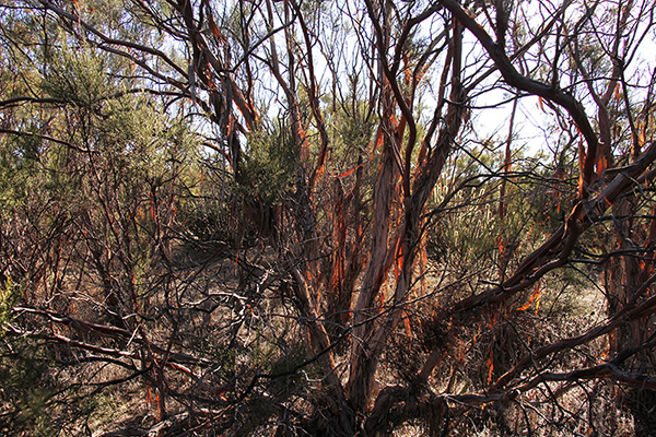
Figure 1. A specimen of red shank in a vegetative lineament in Tierra del Sol
Ecohydrology Study of Red Shank and Water Lineaments in Tierra del Sol,
San Diego County, California
Marcela I. DíazDecember 9, 2015
|
|
ABSTRACT.
This study seeks to establish a relationship between larger than usual Red Shank specimen (Adenostoma sparsifolium),
a type of chaparral native to the Southern California Coastal Range, and water gradients found in the substrate of the Tierra del Sol Watershed. Such water gradients are due to the presence of fractures in the region's underlying rock, through which water convects.
The red shank species have morphological and phenological traits that strongly suggest adaptability to shallow substrate moisture. The larger than usual size of species found in Tierra del Sol suggest that there is a permanent source of moisture, that allows for unparallel growth of such chaparral species. |
1. INTRODUCTION
Tierra del Sol is a wastershed located in the southeast corner of San Diego County in California, just north of Baja California, Mexico. The underground water system is made up predominantly of rock fractures through which water is convected, rather than by the commonly found systems of water diffusion through porosity in the soil. Such rock fractures produce water lineaments which can be seen through line forests made up primarily of chaparral bushes and especially, red shanks, which are a type of chaparral than can grow higher than the average chaparral height if water is readily available. Moisture measurements in the soil at two predetermined sites are being done fortnightly since March of 2015, and will continue until two years of measurements have been completed in February of 2016. With the purpose of establishing that the water lineaments provide a substantial and perennial source of moisture, to the ever growing red shank.
2. TIERRA DEL SOL WATERSHED
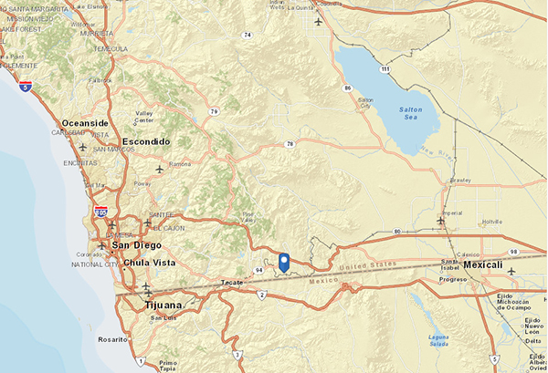
Tierra del Sol is a 2.75 square-mile wastershed located in the southeast corner of San Diego County in California, just north of Baja California, Mexico. It is a chaparral ecosystem with semi-arid climate. The mean annual precipitation is approximately 360 mm, but the annual precipitation varies widely from as low as 89 mm (measured in 1992), to as high as 780 mm (2002). The watershed drains in gentle slopes primarily in a southern direction towards the drainage point (design point) located at 32° 35' 57.61" N and -116° 20' 55.1" W. The maximum elevation of 3864 ft. is located at the north end of the basin, and the minimum elevation, located at the pour point is 3428 ft. The land use in the watershed consists primarily of open spaces and rural housing, and the whole basin has soils with high infiltration rates when thoroughly wet (soil type A).
Figure 2. Location of Tierra del Sol Watershed.
2. DESCRIPTION OF RED SHANK
The red shank is a perennial shrub native to California, USA, and Baja California, Mexico. This erect tree-like shrub grows 6 to 18 feet high, and has a red-brown bark. It is found in dry, chaparral slopes and mesas. It is distributed along South Coast and Transverse ranges from south-central San Louis Obispo County to Los Angeles County, where distribution shifts inland to interior regions of the Peninsular Ranges and the Sierra San Pedro Matir. It is found up to 150 miles south of the US-Mexico border in Baja California. The
total range of the species is approximately 300 miles (480 km) in extent
(latitude 30 deg 30 min N. to latitude 35 deg 30 min N; longitude 115
deg 40 min W. to longitude 120 deg 30 min W). The largest red
shank populations are in the San Jacinto and Santa Rosa mountains and
in interior valleys of Riverside and San Diego counties.
Only 2.5 percent of California's chaparral formation is dominated by red
shank. Total area occupied by red shank communities is 291,700 acres
(116,680 ha).
Red shank is a native arborescent shrub. It has a rounded growth form with thick multiple
branches that ascend several feet without foliage before multiple
smaller branches display leaves. Red shank is classified as a
broad-leaved sclerophyll. The bark
exfoliates freely, peeling off in long strips. It's leaves are covered with a sticky
resin that may serve to reflect excess radiation, this plant burns rapidly but resprouts readily after fire. Red shank may live over 100
years.
Red shank and chamise (Adenostoma fasciculatum) are the only two species in the genus, there are no known subspecies, varieties, or forms of red shank. Although they are congeners these two species are very different in appearance. Chamise chaparral are dull, dark green in color and grow between 2 to 8 feet On the other hand, red shank is much taller and have reddish tinged bark that peels off in the form of ribbons.These two species do not naturally hybridize because their flowering periods do not overlap. Red shank is a dominant species in chamise, mixed, redshank and desert chaparral, coastal sage scrub, and singleleaf pinyon-Utah Juniper woodland.
Red shanks usually have shallow succulent roots, which suggests that its moisture for summer growth comes from top layers of the substrate. The water affinities of the red shank lie in between xerophytes, which are well adapted to drought, and those of the mesophytes, which habitually require a more sustained moisture source. This ecological niche must be connected to the presence of groundwater. Red shank has
a large lignotuber; the lignotuber of one individual in the Santa Monica
Mountains measured 12 inches (30 cm) in diameter.
Control of Red Shank is acheived by spring aerosol application of glyphosate. Follow-up spraying is indicated for long-term control of sprouts. A
single application of glyphosate kills chamise's lignotubers but not red shank's. Spraying red shank with 2,4-D or 2,4,5-T is ineffective.
Native Americans used an infusion of red shank bark and leaves to treat
syphilis. The plant oils were used to relieve skin infections. Spanish Californians used red shank as a remedy for colds, snakebite,
and tetanus.
Counties in California where red shanks are found are shown and listed below.
Figure 3.
Map of counties in California where red shank is present.
Table 1. California Counties where specimens of red shank are found.
|
| No. |
County |
| 1 |
San Diego |
| 2 |
Los Angeles |
| 3 |
Riverside |
| 4 |
Santa Barbara |
| 5 |
San Luis Obispo |
| 6 |
Monterey |
| 7 |
Ventura |
| 8 |
San Bernardino |
| 9 |
San Benito |
| 10 |
Santa Clara |
| 11 |
Orange |
| 12 |
Marin |
| 13 |
San Mateo |
| 14 |
Imperial |
15 |
Santa Cruz |
|
4. ROCK FRACTURES AND VEGETATIVE LINEAMENTS
Lineaments have generally been used as an indicative tool for locating underground water potential zones. In areas where the subsoil has very low primary intergranular porosity, such as rock found in the Tierra del Sol watershed, the permeability is almost entirely associated with fracturing.
Thus, tectonic features and particularly faults, fault zones and fracture zones play a significant role with respect to groundwater flow in hard rock terrains. Faults and fracture zones may be areas of preferential flow. High water production areas in fractured aquifers are often associated with visible lineaments at the ground surface.
It is common assumption in lineament mapping for exploration of groundwater that these features represent vertical zones of fracture concentration.
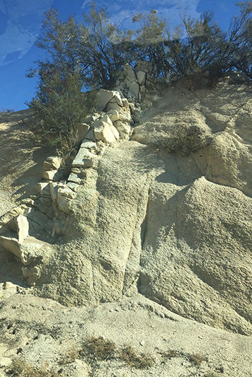
A dyke such as the one seen in Fig. 4 could be an indicator of a highly transmissive fractured zone or a potential flow barrier.
Figure 4. Presence of dykes in Tierra del Sol, indicators of fractured
rock and water lineaments.
There are a number of methods in which lineaments could be identified.
An effective technique for delineation of fracture zones is based on lineament indices extracted from air photos and from satellite imagery.
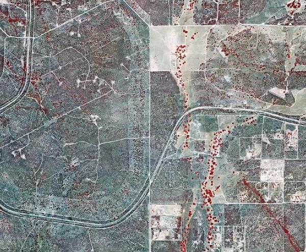
Image processing systems are ideal for mapping lineaments. The accuracy of mapped features increases because there are no intermediate digitized steps. Scale is easily confirmed and it is easier to match to existing maps. The following is an infrared image of the Tierra del Sol watershed, which clearly shows where lineaments are believed to be located.
Figure 5. Infrared image of water lineaments in Tierra del Sol. .
Structural features in hard rock are often visible on remote sensing data as topographic, drainage, vegetation, or soil tonal anomalies.
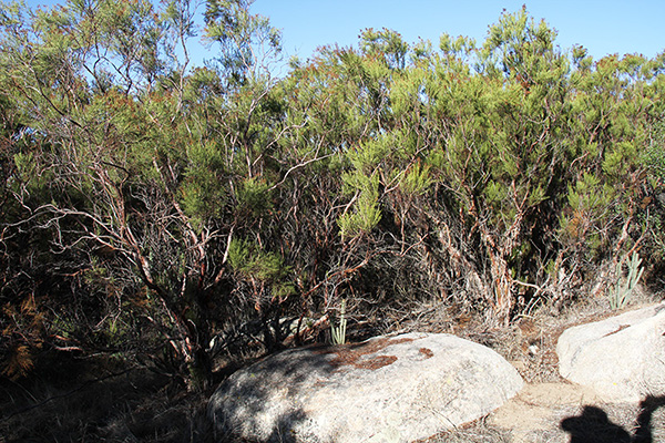
The following image is an upclose view of the linear vegetative forests, primarily consisting of red shank and chaparral. The red shank in this area have grown much higher than the average chaparral, which clearly indicates the presence of water, even though the area is semi-arid with very low mean annual precipitation.
Figure 6. Image of vegetative forest
5. METHODOLOGY
The first step in the study was to determine the location of the measurement sites or boreholes. Several factors where considered, including safety and accesibility. The boreholes are located in a clearing within property where there would be no illegal trespassing. The boreholes are not located within the vegetative lineaments, where it is surmised that there is a more predominent presence of moisture, because of extensive wildlife, which pose a threat to the people involved in the measurements.
Two Collection Sites were established in the field. These sites consist of two sampling locations each (a) a wet location, situated within a water lineament (b) a dry location, offset at a reasonable distance from a lineament, these serve as control locations. A third site had been chosen as well but was deemed not plausible because bedrock was found too close to the surface, thus measurements could not be taken further than two feet beneath the soil's surface.
The selection of wet locations was done through a method known as "water witching" where a special metallic rod serves as a magnet which identifies presence of water, through small variations in the magnetic pull below the earth's surface. The following video shows the process done by Ed Tisdale, who is known in the area to have a long history of succesfull water witching.

Water Witching
|
In December of 2014 a six-foot deep hole was drilled for each of the sites that were to be studied, and 7-ft polycarbonate tubes that are compatible with a moisture sensor device were inserted. These holes were then left to rest for three months in order for the soil to compact normally.
Moisture measurements will be taken fortnightly for two years (two hydrologic cycles) at each of the sites. Measurements began in March of 2015. Special attention has been given to the gravitational pull of the moon, filed work is done in the occurence of full moon and new moon alternatively.
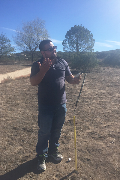
Soil moisture measurements are recorded at several specified depths (3, 6, 9, 12, 18, 24, 30, 42, 54, 66, and 78 inches) with an Aqua-Pro "capacitance" moisture sensor, which is inserted into the previously installed polycarbonate tubes. The moisture probe transmits a very low powered radio frequency through the soil to measure moisture. The readout from the sensor is percent available moisture.
Figure 7. Luis Magallon taking soil moisture measurements.
5. FIELD MEASUREMENTS TO DATE
Table 2 shows the set of field measurements of soil moisture, beginning on 150320 and continuing to date, one set taken every approximately 14 days. A cursory examination of the data of Cols. 7 to 10 of Table 2 shows that the target points, labeled A (Cols. 7 and 9), show comparably higher levels of soil moisture than the control points, labeled B (Cols. 8 and 10).
Table 2. Moisture sensor data.
|
| Number |
Date
[yrmody] |
Time
[hr:mi] |
Day of
the week |
Moon
phase |
Depth
(in) |
Sensor |
Intervening
precipitation
(in) |
1A |
1B |
2A |
2B |
| (1) |
(2) |
(3) |
(4) |
(5) |
(6) |
(7) |
(8) |
(9) |
(10) |
(11) |
| 0 |
150320 |
10:00 |
Friday |
New
 |
6 |
0 |
0 |
0 |
0 |
-
|
| 9 |
0 |
0 |
0 |
0 |
| 12 |
14 |
15 |
0 |
0 |
| 18 |
23 |
17 |
1 |
1 |
| 24 |
24 |
23 |
6 |
2 |
| 30 |
32 |
29 |
11 |
0 |
| 42 |
27 |
23 |
2 |
1 |
| 54 |
14 |
2 |
1 |
0 |
| 66 |
3 |
2 |
0 |
0 |
| 78 |
20 |
0 |
0 |
0 |
| 1 |
150406 |
10:00 |
Monday |
Full
 |
6 |
0 |
0 |
0 |
0 |
0.00 |
| 9 |
0 |
0 |
0 |
0 |
| 12 |
4 |
0 |
1 |
0 |
| 18 |
9 |
0 |
0 |
0 |
| 24 |
8 |
2 |
0 |
0 |
| 30 |
15 |
5 |
3 |
0 |
| 42 |
14 |
3 |
1 |
1 |
| 54 |
11 |
1 |
0 |
0 |
| 66 |
3 |
0 |
0 |
0 |
| 78 |
17 |
0 |
0 |
0 |
| 2 |
150419 |
11:00 |
Sunday |
New
|
6 |
0 |
0 |
0 |
0 |
0.00 |
| 9 |
0 |
0 |
0 |
0 |
| 12 |
0 |
0 |
0 |
0 |
| 18 |
3 |
0 |
0 |
0 |
| 24 |
1 |
0 |
0 |
0 |
| 30 |
5 |
1 |
6 |
0 |
| 42 |
3 |
0 |
2 |
2 |
| 54 |
4 |
0 |
0 |
0 |
| 66 |
2 |
0 |
0 |
0 |
| 78 |
11 |
0 |
0 |
0 |
| 3 |
150504 |
10:00 |
Monday |
Full
|
6 |
0 |
0 |
0 |
0 |
0.40 |
| 9 |
0 |
0 |
0 |
0 |
| 12 |
1 |
0 |
0 |
0 |
| 18 |
2 |
0 |
4 |
0 |
| 24 |
0 |
0 |
1 |
0 |
| 30 |
3 |
1 |
5 |
0 |
| 42 |
1 |
0 |
2 |
1 |
| 54 |
2 |
0 |
0 |
0 |
| 66 |
0 |
0 |
0 |
0 |
| 78 |
10 |
0 |
1 |
0 |
| 4 |
150518 |
10:00 |
Monday |
New
|
6 |
0 |
0 |
0 |
0 |
2.96 |
| 9 |
0 |
27 |
0 |
0 |
| 12 |
33 |
27 |
0 |
1 |
| 18 |
37 |
30 |
42 |
41 |
| 24 |
45 |
29 |
51 |
23 |
| 30 |
49 |
5 |
11 |
2 |
| 42 |
9 |
1 |
5 |
6 |
| 54 |
10 |
0 |
2 |
2 |
| 66 |
7 |
0 |
0 |
0 |
| 78 |
3 |
0 |
0 |
0 |
| 5 |
150602 |
10:00 |
Tuesday |
Full
|
6 |
0 |
0 |
0 |
0 |
0.00
|
| 9 |
0 |
0 |
0 |
0 |
| 12 |
3 |
6 |
0 |
0 |
| 18 |
16 |
7 |
22 |
8 |
| 24 |
16 |
14 |
34 |
11 |
| 30 |
23 |
4 |
34 |
2 |
| 42 |
6 |
1 |
5 |
4 |
| 54 |
8 |
0 |
2 |
2 |
| 66 |
2 |
0 |
1 |
1 |
| 78 |
1 |
0 |
0 |
0 |
| 6 |
150616 |
10:00 |
Tuesday |
New
|
6 |
0 |
0 |
0 |
0 |
0.50 |
| 9 |
0 |
0 |
0 |
0 |
| 12 |
0 |
1 |
0 |
0 |
| 18 |
7 |
2 |
3 |
2 |
| 24 |
7 |
6 |
8 |
3 |
| 30 |
16 |
7 |
14 |
5 |
| 42 |
4 |
1 |
6 |
4 |
| 54 |
7 |
1 |
2 |
1 |
| 66 |
2 |
0 |
0 |
0 |
| 78 |
1 |
0 |
0 |
0 |
| 7 |
150702 |
10:00 |
Thursday |
Full
|
6 |
0 |
0 |
0 |
0 |
0.60 |
| 9 |
0 |
16 |
0 |
0 |
| 12 |
14 |
1 |
0 |
0 |
| 18 |
3 |
0 |
9 |
0 |
| 24 |
1 |
3 |
5 |
1 |
| 30 |
6 |
5 |
12 |
3 |
| 42 |
3 |
2 |
8 |
4 |
| 54 |
6 |
0 |
2 |
2 |
| 66 |
3 |
0 |
1 |
0 |
| 78 |
1 |
0 |
0 |
0 |
| 8 |
150716 |
10:00 |
Thursday |
New
|
6 |
0 |
0 |
0 |
0 |
0.00 |
| 9 |
0 |
0 |
0 |
0 |
| 12 |
0 |
0 |
0 |
0 |
| 18 |
6 |
1 |
2 |
1 |
| 24 |
2 |
2 |
4 |
2 |
| 30 |
6 |
4 |
9 |
3 |
| 42 |
3 |
2 |
6 |
4 |
| 54 |
5 |
0 |
1 |
1 |
| 66 |
3 |
0 |
1 |
0 |
| 78 |
1 |
0 |
0 |
0 |
| 9 |
150731 |
10:00 |
Friday |
Full
|
6 |
0 |
0 |
0 |
0 |
0.75 |
| 9 |
0 |
1 |
0 |
0 |
| 12 |
13 |
5 |
0 |
0 |
| 18 |
13 |
1 |
12 |
2 |
| 24 |
2 |
2 |
6 |
2 |
| 30 |
6 |
4 |
11 |
2 |
| 42 |
3 |
2 |
8 |
4 |
| 54 |
4 |
1 |
1 |
1 |
| 66 |
1 |
0 |
1 |
0 |
| 78 |
0 |
0 |
0 |
0 |
| 10 |
150814 |
09:00 |
Friday |
New
|
6 |
0 |
0 |
0 |
0 |
0.00 |
| 9 |
0 |
0 |
0 |
0 |
| 12 |
0 |
0 |
0 |
0 |
| 18 |
5 |
1 |
0 |
0 |
| 24 |
2 |
2 |
6 |
2 |
| 30 |
7 |
4 |
10 |
4 |
| 42 |
3 |
2 |
7 |
5 |
| 54 |
4 |
1 |
1 |
2 |
| 66 |
2 |
1 |
1 |
0 |
| 78 |
1 |
0 |
0 |
0 |
| 11 |
150828 |
14:00 |
Friday |
Full
|
6 |
0 |
0 |
0 |
0 |
0.65 |
| 9 |
0 |
15 |
0 |
0 |
| 12 |
26 |
0 |
0 |
0 |
| 18 |
3 |
1 |
5 |
0 |
| 24 |
2 |
2 |
4 |
1 |
| 30 |
6 |
4 |
11 |
3 |
| 42 |
3 |
3 |
7 |
5 |
| 54 |
4 |
1 |
3 |
2 |
| 66 |
2 |
1 |
0 |
0 |
| 78 |
1 |
0 |
0 |
0 |
| 12 |
150912 |
10:00 |
Saturday |
New
|
6 |
0 |
0 |
0 |
0 |
0.00 |
| 9 |
0 |
0 |
0 |
0 |
| 12 |
0 |
0 |
2 |
0 |
| 18 |
3 |
1 |
1 |
0 |
| 24 |
1 |
2 |
5 |
1 |
| 30 |
6 |
4 |
11 |
2 |
| 42 |
3 |
1 |
7 |
4 |
| 54 |
4 |
1 |
2 |
2 |
| 66 |
2 |
0 |
1 |
0 |
| 78 |
1 |
0 |
0 |
0 |
| 13 |
150928 |
08:30 |
Monday |
Full
|
6 |
0 |
0 |
0 |
0 |
0.37 |
| 9 |
0 |
15 |
0 |
0 |
| 12 |
5 |
2 |
0 |
0 |
| 18 |
5 |
1 |
6 |
2 |
| 24 |
2 |
2 |
4 |
1 |
| 30 |
6 |
3 |
9 |
3 |
| 42 |
3 |
2 |
7 |
5 |
| 54 |
4 |
1 |
2 |
2 |
| 66 |
1 |
0 |
0 |
1 |
| 78 |
0 |
0 |
0 |
0 |
| 14 |
151013 |
09:30 |
Tuesday |
New
|
6 |
0 |
0 |
0 |
0 |
0.00 |
| 9 |
0 |
0 |
0 |
0 |
| 12 |
1 |
0 |
0 |
0 |
| 18 |
58 |
1 |
1 |
0 |
| 24 |
23 |
2 |
4 |
1 |
| 30 |
87 |
2 |
9 |
2 |
| 42 |
30 |
1 |
6 |
3 |
| 54 |
68 |
0 |
2 |
2 |
| 66 |
35 |
0 |
0 |
0 |
| 78 |
1 |
0 |
0 |
0 |
| 15 |
151027 |
10:00 |
Tuesday |
Full
|
6 |
0 |
0 |
0 |
0 |
0.13 |
| 9 |
0 |
15 |
0 |
0 |
| 12 |
26 |
0 |
0 |
0 |
| 18 |
16 |
1 |
0 |
0 |
| 24 |
12 |
19 |
53 |
0 |
| 30 |
70 |
32 |
100 |
20 |
| 42 |
23 |
18 |
100 |
9 |
| 54 |
46 |
0 |
29 |
32 |
| 66 |
32 |
0 |
0 |
1 |
| 78 |
1 |
0 |
0 |
0 |
| 16 |
151111 |
09:30 |
Wednesday |
New
|
6 |
0 |
0 |
0 |
0 |
0.58 |
| 9 |
0 |
0 |
0 |
0 |
| 12 |
100 |
25 |
0 |
0 |
| 18 |
20 |
0 |
100 |
27 |
| 24 |
0 |
0 |
6 |
0 |
| 30 |
2 |
10 |
32 |
0 |
| 42 |
0 |
0 |
19 |
0 |
| 54 |
9 |
0 |
0 |
0 |
| 66 |
0 |
0 |
0 |
0 |
| 78 |
0 |
0 |
26 |
0 |
| 17 |
151125 |
09:30 |
Wednesday |
Full
|
6 |
0 |
0 |
0 |
0 |
0.25 |
| 9 |
0 |
8 |
0 |
0 |
| 12 |
100 |
25 |
0 |
0 |
| 18 |
47 |
0 |
100 |
15 |
| 24 |
0 |
3 |
25 |
0 |
| 30 |
19 |
17 |
21 |
0 |
| 42 |
17 |
0 |
24 |
0 |
| 54 |
1 |
0 |
0 |
0 |
| 66 |
0 |
0 |
0 |
0 |
| 78 |
0 |
0 |
0 |
0 |
6. DATA ANALYSIS TO DATE
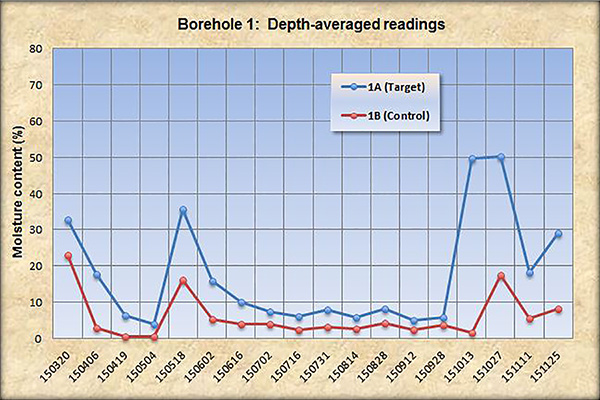
The data has been analyzed in two ways: taking into account a depth average of each set of readings per locations per measurement day; and taking the highest moisture reading of each location per measuring day. The target and control location measurements were then compared. Figures 8-11 illustrate plots of the results to date, covering the eight month period from March 20th, 2015 to November 11th, 2015. Figures 8 and 9 show the depth-averaged moisture content readings from borehole 1 and 2, respectively; while, Figures 10 and 11, show the maximum readings throughout the different depths for each of the boreholes. The last two graphs compare the results with the corresponding precipitation.
|
Figure 8. Borehole 1: Depth-averaged readings.
|
|
|
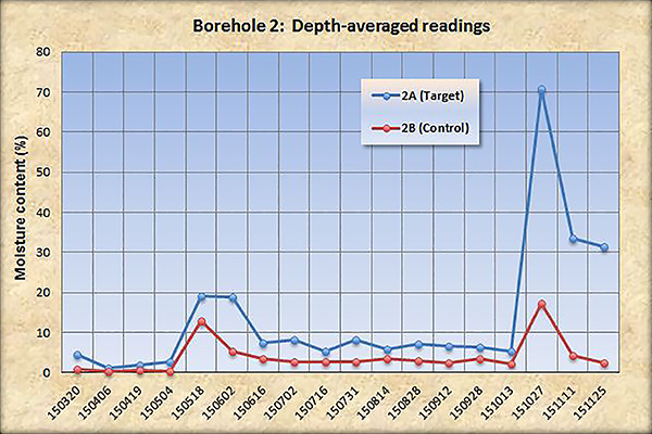
Figure 9 Borehole 2: Depth-averaged readings.
|
|
|
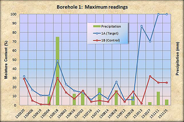
Figure 10. Borehole 1: Maximum readings vs precipitation.
|
|
|
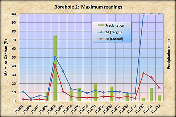
Figure 11. Borehole 2: Maximum readings vs precipitation.
|
|
The plots clearly show that the moisture content in the target points (wet points) is consistently and substantially higher than that of the control points (dry points). Even though 2015 has been a dry year, some measurements have reached 100% of moisture, which points to the presence of concentrated leakage from the underlying fractured rock aquifer. It is highly probable that the=is is the moisture source for the red shank vegetative lineaments in the region.
A few more visits are scheduled before the end of this project. Results to date are encouraging, up to now the tendency of the measurements support the idea of presence of water lineaments due to rock fractures in the subsoil, which could be the reason why the red shank specimen in the area have grown so remarkably. It is expected that continued measurement to the span period of 2 years should confirm the trend. More detailed analysis will be forthcoming upon completion of the measurement program.
7. CONCLUSIONS
The Tierra del Sol watershed is a chaparral ecosystem with semi-arid climate. It is a region underlain by fractured rock in the substrate. The presence of larger than average species of red shank, a type of chaparral, is of particular interest to this study. The physiological characteristics of the red shank root system suggests that moisture is acquired from the shallow substrate of the subsoil. The existence of soil moisture gradients in the Tierra del Sol watershed has been documented by underground moisture measurements. These gradients are due to convection of water along the rock fractures.
The measurements clearly illustrate that there is a difference in moisture between the target and control points.
This points to differential leakage from the groundwater along fracture planes. The target (wet) locations consistently present more moisture than the control (dry) locations. It is surmised that the presence of localized moisture correlates with the presence of the vegetative lineaments of red shank. Even though 2015 has been a dry year, some measurements have reached 100% of moisture, which points to the presence of concentrated leakage from the underlying fractured rock aquifer. More measurements will clarify the relationship between the red shank species and the vegetative lineaments.
7. REFERENCES
Ponce and Magallon; February 2014; Ecohydrology of Red Shank in the Tierra del Sol Watershed, San Diego, California.
University of California, Berkely; A. Sparicufolium; http://ucjeps. berkely.edu/cgi-bin/LN2C.pl
http://plants.usda.gov/Adenostomasparsifolium)
http://calflora.org/
http://www.fs.fed.us/database/feis/
Lineamente in groundwater exploration: a review of applications and limitations; Per Sander; Hydrolgeology Journal; February 207
Groundwater Exploration Based on Lineament Analysis and Reproducibility Tests; Per sander, Timothy Minor; and Matthew Chesley.
Relationships between lineaments and groundwater occurrence in Western Botswana; Magowe Magowe and James R Carr.
|