|
|
|
| 1. DEFINITION |
|
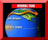
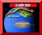
Variations in climate and weather can significantly affect people's lives. Humans are linked to their ecosystem through climatic events such as extremely cold winters, persistent droughts, or emergencies such as flooding, heat waves, or forest fires. Effective planning requires study and analysis of the climatic variabilities, notably among them, those associated with El Niño. El Niño is related to the Southern Oscillation, which is a seesaw of air pressures on the eastern and western halves of the Pacific Ocean. Normally the atmosphere above the eastern South Pacific is dominated by a persistent high-pressure zone, while a low-pressure zone dominates the western portion. These two systems are coupled; when the pressure rises in the east, it falls in the west, and vice versa. To measure this coupling, meteorologists take the pressure at Easter Island, about 2,700 miles west of South America, and subtract it from the pressure at Darwin in northern Australia, and from this difference they calculate the Southern Oscillation Index (SOI). Under normal conditions, this difference in pressure drives the trade winds from east to west along the equator, i.e., the easterlies. At the same time, high above the ocean surface, the wind circulation is completed as it continues to blow around from west to east. This convection of air is called the Walker Cell circulation, after Sir Gilbert Walker, who identified it in the 1920's. Every 2 to 7 years, the SOI becomes negative. The east end of the pressure seesaw goes down, the west end goes up, and the Walker Cell collapses and sometimes reverses direction. With the collapse of the winds comes the characteristic warm flow of water to the east, and the normally cold waters on the South American coast warm up by 2o to 8oC. All of these elements combine to form the phenomenon called El Niño, characterized by a dwindling, and sometimes a reversal, of the trade winds, which causes unusual warming of sea-surface temperatures along the tropical eastern Pacific.
|
| 2. HISTORY |
|
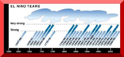
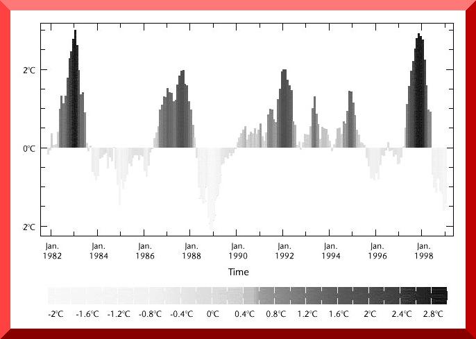
There is a historical record of an El Niño event going back to 1567. Peruvian fishermen along the westernmost shores of South America were the first to give a name to the climatic anomaly. In a normal year, the waters were cold and flowed from south to north; however, every few years, the waters reversed their flow and warmed up. The phenomenon usually began to peak around Christmas; therefore, the fishermen named the odd weather "El Niño," which means "The Child Jesus," in reference to the Christmas holiday. In the early 20th century, the concept of El Niño gradually spread through the world's scientific community. At the beginning, scientists believed this strange phenomenon occurred independently of other weather patterns. During the 1920's, while scientists in South America were busy documenting the local effects of El Niño, a British scientist, Sir Gilbert Walker, separately noted that climate anomalies occurred around the world every few years. As Sir Walker sorted through world weather records, he recognized some patterns of rainfall in South America, and associated them with changes in ocean temperatures. He found a connection between barometer readings at stations on the eastern and western sides of the Pacific (Tahiti and Darwin). He noticed that when pressure rises in the east, it usually falls in the west, and vice versa. He coined the term Southern Oscillation to emphasize the ups and downs of this east-west seesaw effect. He also realized that, under certain barometric conditions, the Asian monsoon seasons were often linked to drought in Australia, Indonesia, India, and parts of Africa, and mild winters in western Canada. He was the first person to claim a connection between the monsoons in India and unusually mild winters in Canada. In the late 1960's, Jacob Bjerknes, a Norwegian meteorologist, proposed that El Niño was the oceanic expression of a large-scale interaction between the ocean and the atmosphere, and that the climate anomalies could be better understood as atmospheric teleconnections emanating from the warm-water regions of the mid-Pacific along the equator. Starting at about 1975, oceanographers and meteorologists began to combine their efforts to expand and refine the Bjerknes hypothesis by systematically studying El Niño and the Southern Oscillation together in what is now referred to as "El Niño-Southern Oscillation" (ENSO). The 1982-83 El Niño has been widely recognized as the most severe of the century. North America experienced wildly unusual weather throughout 1983; Australia experienced massive drought and devastating brushfires; it was one of the worst periods for drought in the sub-Sahelian countries, and the monsoons failed in the Indian Ocean. Total damages were estimated at between 8 and 13 billion dollars, and 2,000 lives were lost. After the 1982-83 event, there was a minor respite, followed by another event in 1986-88, and yet another in 1990-95, in what appears to be the longest El Niño of record (Fig. 1). |
|
| 3. CAUSES |
|
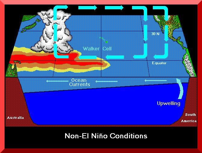
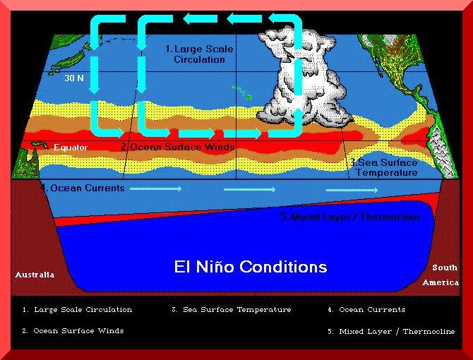
The main cause of El Niño involves the full complexity of oceanic-atmospheric interactions on a global scale. While the cause is not fully known, scientists have a good understanding of how it evolves once it has begun. This provides a useful ability to make forecasts six to nine months in advance for some regions. During normal, or non-El Niño years, the winds at the surface of the Pacific Ocean near the equator blow from the northeast and the southeast, converge at the equator, and move west. These winds are called trade winds because they blow regularly; therefore, trade ships have depended on them to transport their cargo across the ocean. The winds meet in a band parallel to the equator creating a convergence zone. The trade winds drive the ocean currents, causing a flow of surface water in the same direction, from east to west, along the equatorial Pacific. The movement of wind causes the warm surface water to build up in the western Pacific. This region of warm surface water is known as the western Pacific warm pool. The winds also cause stirring in the upper layer of the ocean, which causes warm surface water to be mixed into the deeper ocean. This upper layer, known as the mixed layer, is fairly uniform in temperature, salinity and density. The region which separates the warmer water of the mixed layer from the colder deep ocean water is called the thermocline. The warm-water buildup and the strong surface winds over the western tropical Pacific create a thermocline at approximately 100 m below the surface. In the eastern Pacific, the cold deep ocean waters are upwelled off the coast of South America to replace the wind-blown warm surface water. This produces a shallow thermocline, approximately at 10-50 m of depth. These upwelled waters are rich in nutrients and produce some of the richer fishing waters in the world. In the warm pool region of the western Pacific, the warm surface waters and the strong trade winds cause large amounts of water to evaporate from the ocean surface. The evaporation of the warm, moist air causes the air to rise and creates an atmospheric low-pressure system at the surface. This low-pressure system is known as the Indonesian Low. The rising air encounters lower temperature and pressure at higher altitudes, leading to the formation of intense rain-producing cumulus clouds. Further cooling of the rising clouds produces heavy rainfall over the western Pacific convergence zone. After the water condenses and rains out, the dry air continues to travel aloft. Some of the air mass travels back towards the east and accumulates over the eastern Pacific. The accumulation of air sinks, creating an atmospheric high-pressure system over the eastern tropical Pacific. Very small amounts of rainfall are experienced in the eastern Pacific because the sinking air prevents the formation of strong cloud systems. The difference between surface pressures in the eastern and western Pacific produces a pressure gradient along the equator. Wind naturally moves across the pressure gradient from high pressure to low pressure. This east-west circulation cell is completed as the air mass continues to move westward along the ocean surface, where it again acquires moisture from the evaporating ocean. This pattern of air movement from east to west along the surface and from west to east aloft is the Walker Cell circulation, and it constitutes the east-west component of the large-scale tropical circulation. Figure 2 shows a schematic representation of Non-El Niño (normal) conditions in the tropical Pacific. |
|
|
The north-south component of the large-scale tropical airflow is the Hadley Cell circulation. The Hadley Cell circulation is comprised of two cells which transport heat through the atmosphere from tropical to subtropical latitudes. As the trade winds converge, they create a band of low pressure in the tropics called the Intertropical Convergence Zone (ITCZ). Warm moist air rises along the ITCZ carrying with it latent heat. As the air encounters lower temperatures at higher altitudes, it cools and the moisture condenses, releasing latent heat. The moisture condensation can eventually lead to cloud formation and rainfall. After the moisture condenses and rains out, the dry air continues to travel at high altitudes transporting heat to approximately 30o N and S latitude, where it begins to sink. As the dry air sinks, it compresses and heats up due to increased pressure. The air near the surface returns to the equatorial region, gathering moisture along the way and completing the Hadley Cell circulation. During an El Niño event, several changes occur in the ocean and the atmosphere due to the dynamic and thermodynamic processes described above. Oceanographers and meteorologists do not yet know what initiates an ENSO event, but they are able to identify and describe the changes associated with ENSO. These changes impact atmospheric circulation patterns and can alter climatic conditions across the globe. During the early stages of El Niño, the easterlies weaken and retreat eastward, reducing the upwelling of cool waters in the eastern Pacific, and allowing the pool of warm water in the west to drift eastward toward South America. As the central and eastern Pacific warms, the atmospheric pressure gradient along the equator weakens, and the trade winds diminish even more. The moist air above the ocean also warms and it becomes buoyant enough to form deep clouds which produce heavy rain along the equator. The change in ocean temperatures causes the major rain zone over the western Pacific to shift eastward. Related adjustments in the atmosphere cause barometers to fall over the central and eastern Pacific and rise over Indonesia and Australia, resulting in further weakening and eastward retreat of the easterlies. Figure 3 shows a schematic representation of El Niño conditions in the tropical Pacific.
|
|
| 4. PATTERNS |
|
On the average, an El Niño event occurs every 2 to 7 years, but only irregularly, and not as
predictably as the astronomically controlled tides.
|
|
|
|
| |||||||||||||||||||||||||||||||||||||||||
| |||||||||||||||||||||||||||||||||||||||||
| 5. IMPACTS |
|
The ocean and atmosphere disturbances created by El Niño can have devastating impacts on the environment. Changes in the "normal" weather patterns can bring floods to the driest lands on earth, creating lakes where desert plains normally existed. At the same time, El Niño disturbances can bring drought conditions to the wettest regions of the globe, the rainforests, bringing drought stress and sometimes huge forest fires. The effects are global in nature, and extend as far north as Canada and as far south as New Zealand, and over the entire planet from east to west. The effects are felt on many species, from phytoplankton to humans. Changes in the normal ocean circulation patterns can cause major disturbances in the marine biosphere as sea-surface temperatures change and their associated effects touch all forms of life. The rainfall follows the warm water eastward and results in flooding in Peru and drought in Indonesia and Australia. The change in weather patterns during an ENSO event alters regions of high and low pressures around the globe. Descending air of atmospheric circulation cells creates high-pressure centers at the surface. The high surface pressures prevent areas of precipitation from moving into this region. When these abnormal high-pressure patterns persist, they lead to drought conditions, depriving the area of rainfall. Droughts generally occur in the western Pacific during ENSO events, an area normally rich in rainfall. During El Niño years, droughts have been observed in many regions, including southeastern Africa, India and the northeastern region of South America. During the 1982-83 ENSO event, Australia was hit particularly hard by drought. After several months without rains, brush fires and dust storms ravaged eastern Australia. Droughts were also endured in parts of Indonesia and the Philippines, where rainforests dried out and subsequently ignited into flames. Summer monsoons from the Indian Ocean where blocked from reaching the Indian subcontinent by a high-pressure system, which brought hardship to the people of Southern India. South Africa and Botswana experienced severe drought, with devastating effects on the wildlife and people of the region. The shifting precipitation patterns associated with El Niño can bring heavy rains to areas not accustomed to such amounts. The rains can bring much needed water to dry regions like the Peruvian coast. However, the heavy precipitation can create havoc, causing major flooding and sometimes avalanches if the precipitation falls as snow in higher mountainous areas. Some of the devastating impacts of flooding include loss of human lives, destruction of homes, damage to crops and natural vegetation, loss of livestock and the spreading of diseases. In 1982, during the strongest ENSO on record, Peru recorded its greatest rainfall amounts in over 200 years. The rains drenched northern Peru and Ecuador, creating massive floods in the Piura River and in the Guayaquil area. The flood swollen rivers wiped out the prime banana and rice growing regions, swept away vital bridges and flooded towns, overflowing toilet pits and causing virulent diseases to spread thought the affected areas. The rains soaked hillsides and brought thousands of homes tumbling down in the mudslides. In Australia, near the end of the 1982-83 ENSO event, and directly after having suffered through a devastating drought, torrential rains swept through and flooded large portions of eastern Australia. Tens of thousands of sheep and cattle were stranded in shallow water or on hilltops surrounded by water. Flooding occurred in many other regions of the world, including Brazil, Europe, China, Cuba and the United States. In the United States much of the precipitation fell as snow in the western mountains, delaying the floods until the following spring melt. Also, during moderate to strong El Niño years (where the SOI is at least larger than one standard deviation over the mean), a statistically significant increase in precipitation, and consequent flooding, may be expected in Southern California, as well as in the much broader U.S. Southwest.
Higher sea-surface temperatures in the eastern Pacific provide fertile ground for the development of hurricanes and tropical storms.
The eastern Pacific normally has much cooler water, but warm water invades the area during Upwelling of deep ocean currents off the coast of Peru create one of the most productive fishing waters in the world. The upwelled ocean currents bring nutrient-rich waters to the surface. When ENSO conditions prevail, the upwelling is slowed and sometimes even stopped if the event is strong enough. The reduced upwelling decreases the amount of planktonic diatoms which are at the base of the food chain. Without plankton, higher level life-forms starve or migrate out of the region. Marine species such as zooplankton, macaral, anchoveta, bait fis, and squid perish from the lack of nutrients, disrupting fishing industries. Bird species, which depend on these fish as food sources, also starve or migrate. Often this leads to nest abandonment by nesting birds. In 1983, up to 85% of the seabirds on the Peruvian coast died. During this same time, the Galapagos and Christmas Islands, home to 17 million seabirds, were nearly completely abandoned due to the lack of food. On Christmas Island, this entailed a total reproductive failure for the year. Sea mammals are also affected by the lack of fish. Sea lions and fur seals have been noted to have markedly reduced birth rates in the years following an ENSO event. Albatross, boobies, penguins, cormorants and marine iguanas are other species adversely affected by the lack of food. A compounding problem with El Niño is the timing of the events. The warmest sea-surface temperature and its impacts occur when many mammals are breeding. At a time when food supplies should be highest, El Niño, diminishes food supplies by reducing upwelling and dampening primary food production. Loss of food has particularly detrimental effects on nursing females and their young or unborn. Territorial male mammals suffer due to their inability to move with the migrating food sources. In spite of the destructive nature of El Niño, some marine creatures do benefit from the climatic disturbances. As a result of the 1982-83 El Niño, scallops accelerated their growth and reached enormous densities. Purple snails and octopuses became more common and the shrimp fishery reached its highest level. This is most likely the result of increased runoff from the rivers, which provide a greater abundance of nutrients and decreased predation from a dispersed fish population. Coral reefs are a notably sensitive ecosystem. The temperature increases create thermal stresses which kill endosymbiotic algae which live in the coral. The algae protects the coral from the sun's damaging ultraviolet (UV) radiation. Without the algae, corals suddenly turn white because they are left unprotected against the UV radiation from the sun. The whitening of the coral is known as coral bleaching. Within two to four weeks of the bleaching, the coral skeletal structure is destroyed and the plant dies. The 1982-83 El Niño nearly wiped out many eastern Pacific coral communities. Scientist estimated coral mortality was close to 98% of the total population. Damage was also observed during this period in reefs in the central and western Pacific, Japan, the Persian Gulf and the tropical western Atlantic, with mortalities reaching 70-90% in some regions. The damage to the coral reefs is particularly devastating as recovery occurs over time periods of decades to centuries. |
| 6. SUMMARY |
|
El Niño is a global climatic anomaly caused by a weakening of the trade winds along the tropical Pacific, which leads to warmer-than-normal sea-surface waters along the eastern tropical Pacific.
The name of El Niño originated with Peruvian fishermen, who noticed that reduced fisheries were
associated with the warmer-than-normal waters.
The root cause of El Niño is not known with certainty. Atmospheric scientists attribute it to the large-scale teleconnections emanating from the warm-water regions of the mid-Pacific along the equator. The return period (the reciprocal of frequency) of El Niño is from 2 to 7 years, with an average of 4 years. An event usually lasts from 14 to 22 months. Two consecutive events do not behave in the same way. The strong events occur at 8- to 15-year intervals. El Niño can alter the magnitude and frequency of floods and droughts. Typically, if a region floods, other regions will experience drought. Floods and droughts can lead to extensive damages to life and property. El Niño can also affect biota in diverse ecosystems, including terrestrial and marine. |
|
|
221003
|