Millions of years ago, during the Quaternary Period, the subsidence of strata formed a tectonic trough
that was covered with glacial melt and precipitation and, thus, Lake Titicaca was formed.
Initially, the level of the lake was 60 to 100 m higher
than today's level.
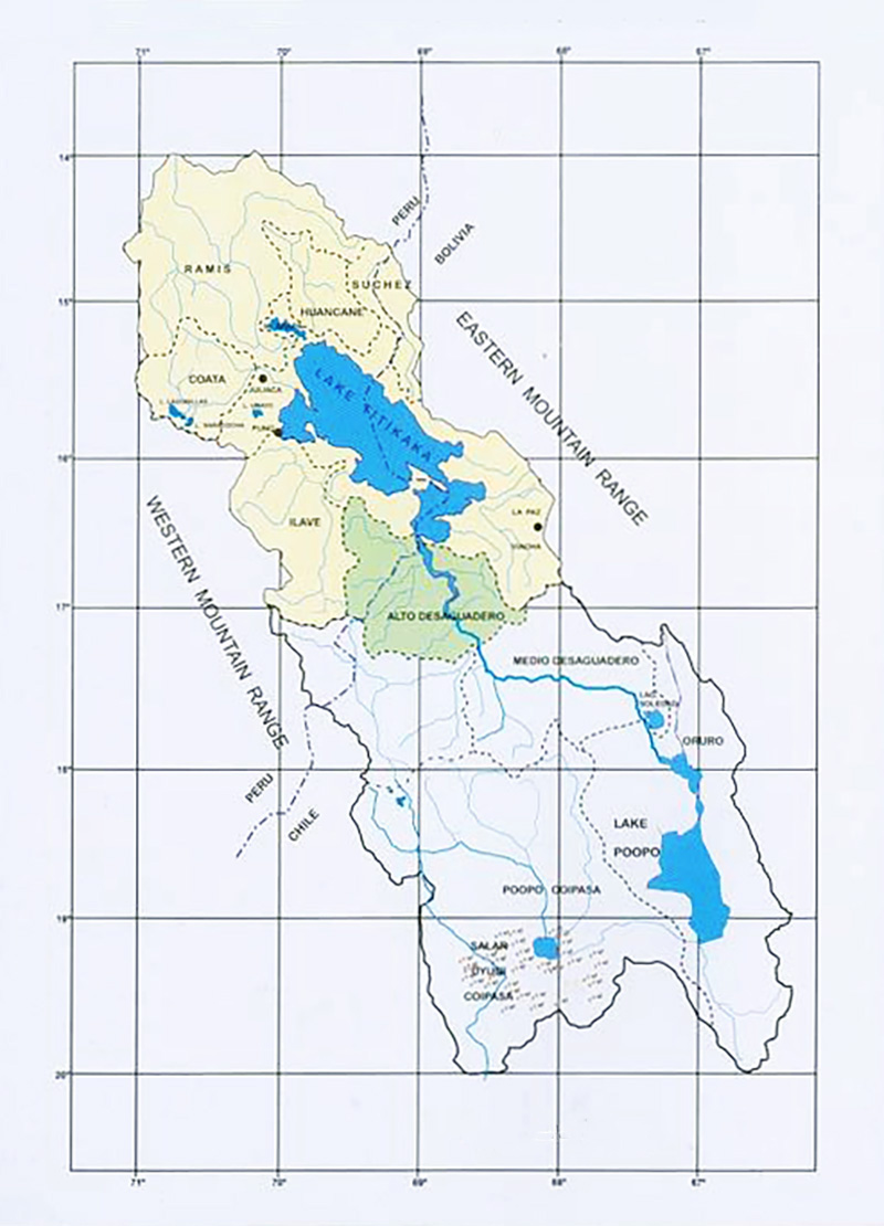
Southward from the Vilcanota knot, at a latitude of about 14°S, the Andes mountain range splits into western and eastern ranges,
forming an extensive relatively flat and high region,
at elevations between 3700 and 4500 m above mean sea level (Fig. 2).
These high plains, locally referred to as altiplanos,
give rise to the Northern, Central, and Southern High Plains, which
lie within Southern Peru and Bolivia.
Lake Titicaca occupies the Northern High Plains;
Lake Poopo, in southcentral Bolivia, occupies the Central High Plains;
and the salt flats of Coipasa and Uyuni, in southernmost Bolivia, occupy the Southern High Plains (Fig. 2).
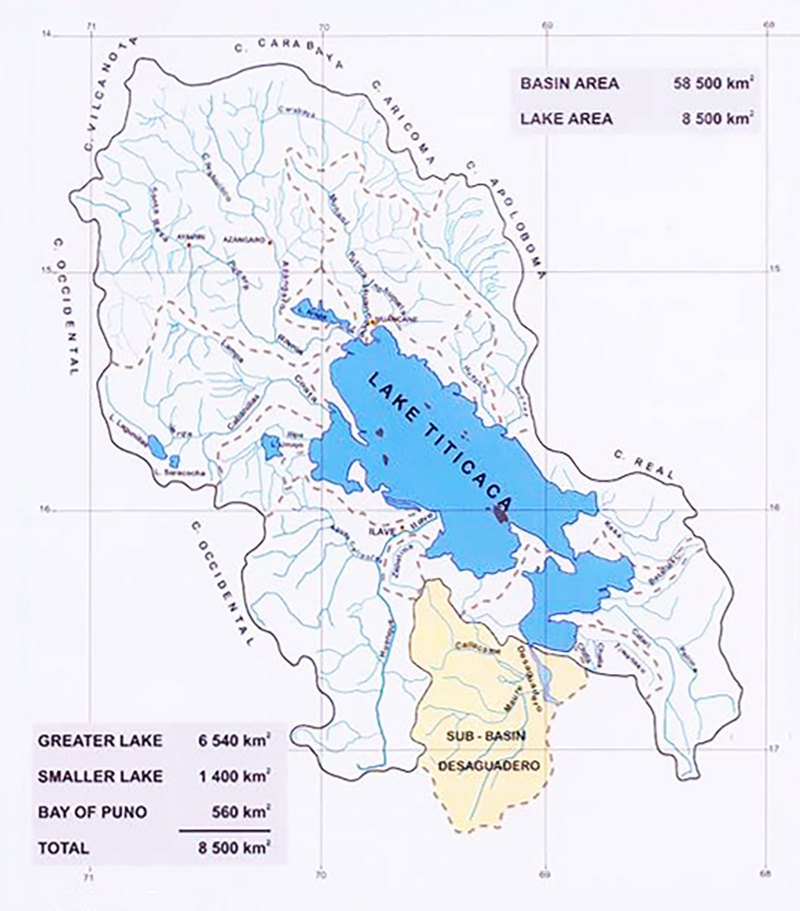
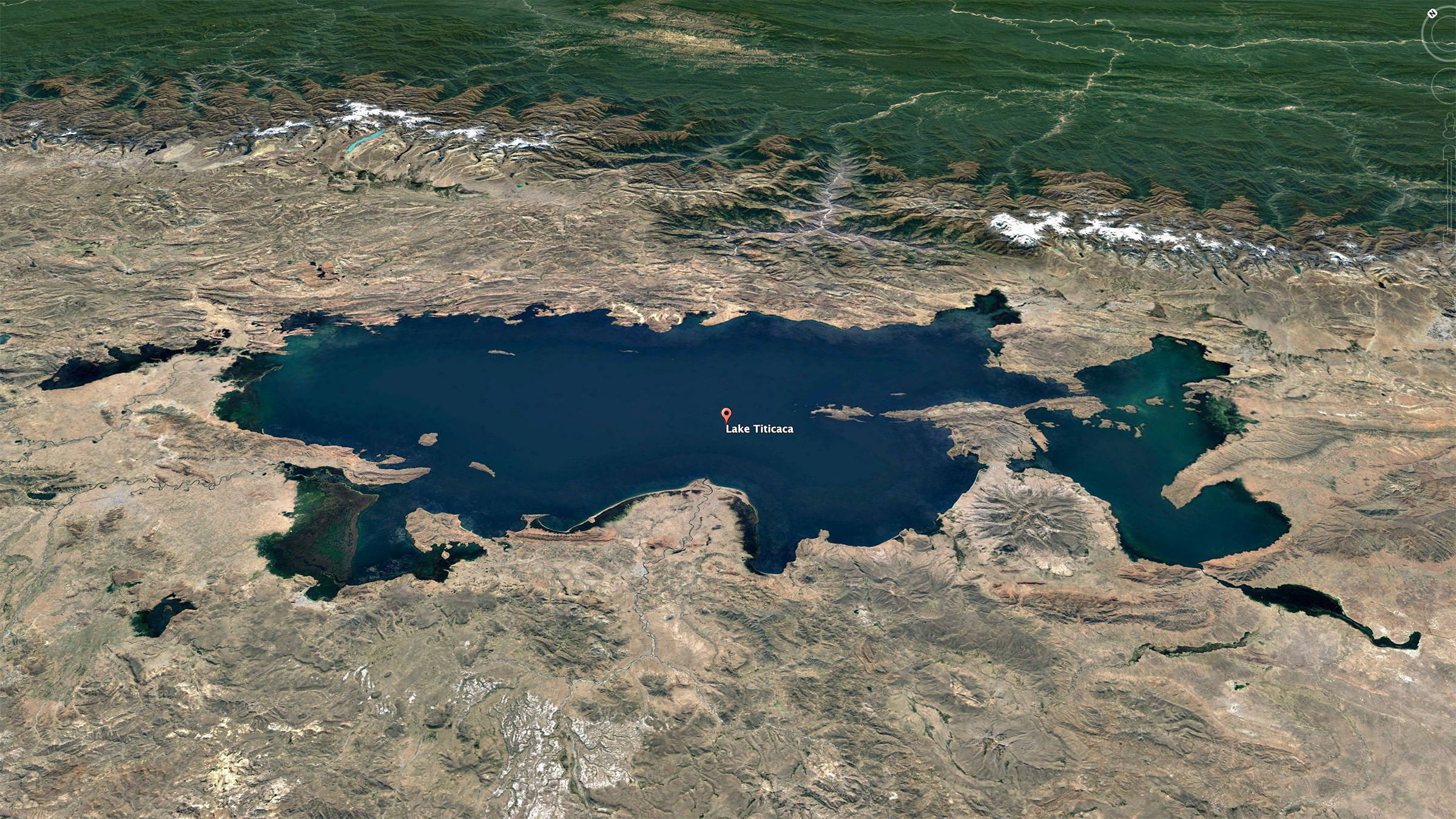
Fig. 2 Hydrographic basin of the Peruvian-Bolivian altiplano.
Lake Titicaca lies within a semiendorheic basin of 58 500 km2,
with the lake itself occupying a surface of 8500 km2 at the average
elevation of 3810 m above mean sea level (Fig. 3).
Fig. 3 Hydrographic basin of Lake Titicaca.
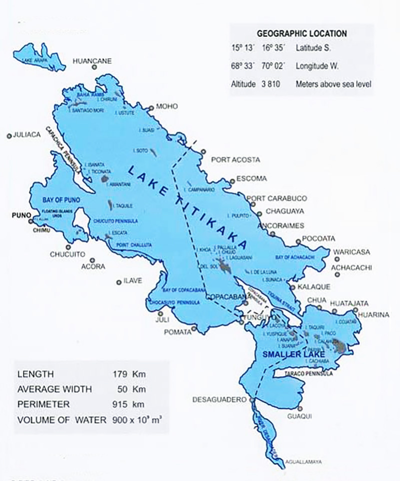
Lake Titicaca is within 15°13' and 16°35' South latitude,
and 68°33' and 70°02' West longitude.
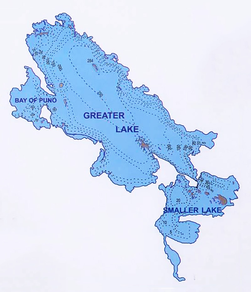
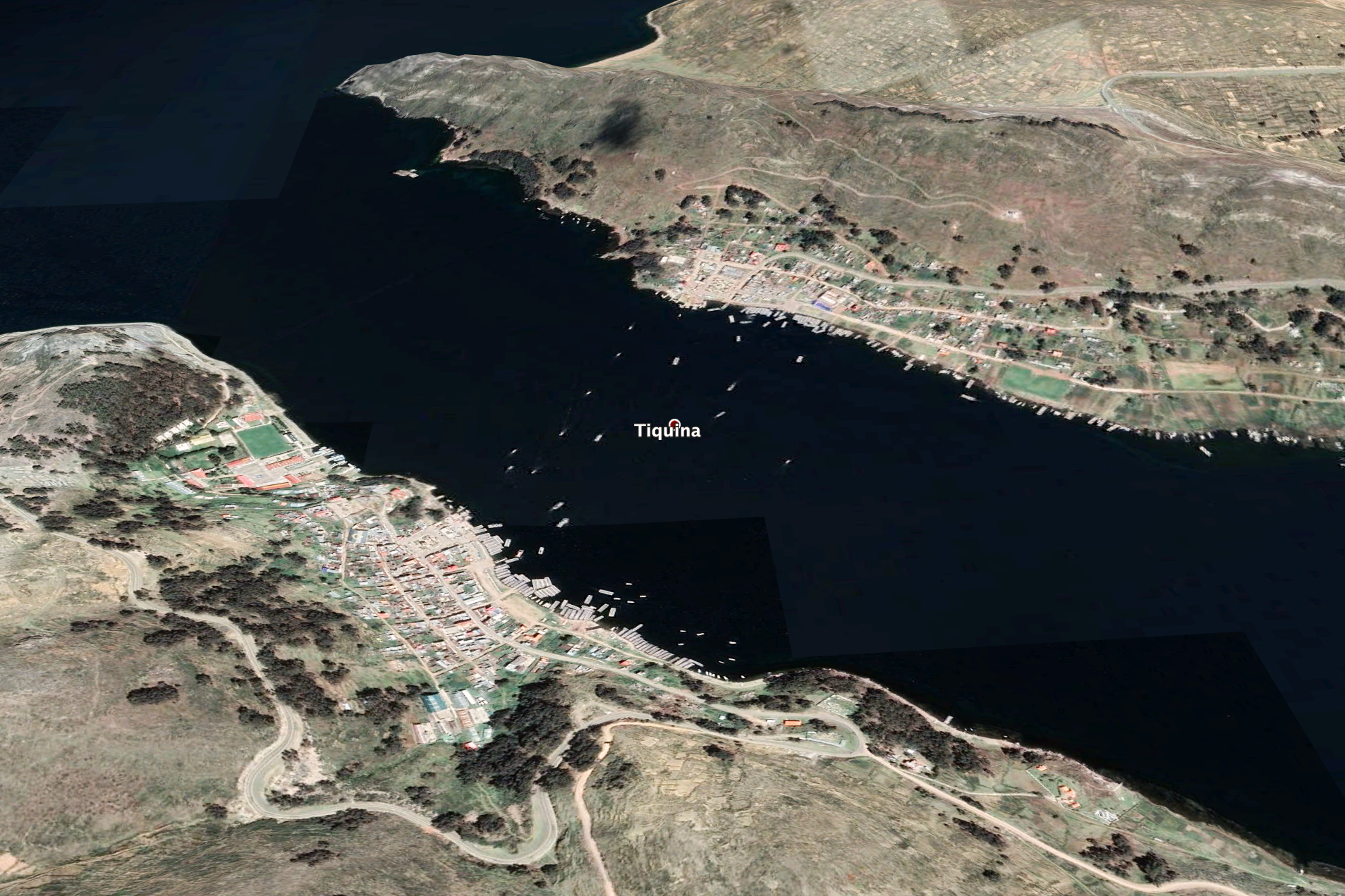
Fig. 4 Geographic details of Lake Titicaca. Tha maximum depth of Lake Titicaca is 284 m (Fig. 5). The lake is divided into two parts: (1) the greater lake, or Chucuito, and (2) the smaller lake, or Huiñaymarca, and connected by the Tiquina Strait, which is 800 m wide and 21 m deep (Fig. 6).
Fig. 5 Bathymetry of Lake Titicaca.
Fig. 6 Tiquina strait, La Paz department, Bolivia.
The source of Lake Titicaca's water is: (a) direct precipitation, and (b) surface runoff from several tributaries. Direct precipitation accounts for 48% and surface runoff for the remaining 52%. Table 1 lists the contribution of permanent rivers (E. Aquize).
The average temperature of Lake Titicaca's water is 13°C, varying between
11°C in the winter and 15°C in the summer.
The lowest temperatures occur in July,
while the highest temperatures occur between December and March, and frequently
in February. The lake's large surface area and great depth, resulting in a large volume of water, produces a thermal regulation effect which is vital for the support of local ecosystems.
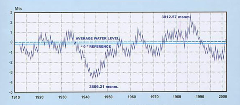
Lake Titicaca's geographic location, within the large endorheic Altiplano basin, makes it behave as if it were a large raingage. The lake levels are measured at a metallic gage in the port of Puno, with the zero (0) level at 3809.09 m above mean sea level. The record of lake levels, measured on a daily basis since 1912, shows the maximum and minimum levels at 3812.57 m (April 1986), and 3806.21 (December 1943), respectively, indicating a total variation of 6.36 m in the period of record (Fig. 7). Minimum lake levels occur at the end of the dry season (December), while maximum levels occur at the end of the wet season (April). The average water surface elevation is 3810 m and the average annual fluctuation in lake level is 0.8 m.
Fig. 7 Variation of Lake Titicaca's water levels throughout the period of record (1912-2002).
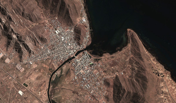
Lake Titicaca's inflow consists of direct precipitation and surface runoff. The total annual outflow follows three paths: (a) 95% is lost through evaporation, (b) 3% percolates to the local aquifers, and (c) the remaining 2% leaves the lake through the Desaguadero river, near the lake's southern extremity, with the riverbed elevation at 3804 m (Fig. 8). The Desaguadero river, the lake's only outlet, has a highly variable annual discharge, with an estimated long-term mean of 10 to 12 m3/s (E. Aquize).
Fig. 8 Aerial view of Lake Titicaca's outlet through Desaguadero river, It is noted that there have been periods lasting days, months, or years, in which the Desaguadero river has reversed its normal course and flowed instead toward the lake. This has been the case when the lake level was either low, or when there had been strong or persistent precipitation in the Callacame and Maure rivers, which flow into the Desaguadero river near its beginning, at the lake's outlet.
The climate of Lake Titicaca and environs is cold semiarid; cold due to the lake's high elevation, at slightly more than 3800 m, and semiarid because of the pronounced dry season (fall and winter) and wet season (spring and summer) (Fig. 9).
Fig. 9 The semiarid climate of Lake Titicaca,
within 50 to 100 km Mean annual precipitation over the terrestrial portion of the Lake Titicaca basin is 736 mm, spanning a rainy season typically lasting four months (Roache et al., 1992). The region's temperature fluctuates between a minimum of -1°C and a maximum of 15°C, with an average of 7°C. However, directly above the lake, the temperature is a bit warmer, varying between 0°C and 16°C, with an average of 8°C. The mean annual relative humidity around the lake varies between 50 and 65%, somewhat lower values of 50 to 45% occurring toward the south. The annual sunshine duration recorded at Puno is 3000 hours (Roache et al., 1992). Solar radiation averages 515 calories/cm2/day and atmospheric pressure is 646 millibars. Table 2 summarizes pertinent Lake Titicaca's climatological data.
The continental location of Lake Titicaca, next to the
hot and humid Amazon basin toward the east,
the dry coastal Pacific region toward the west,
and the frigid weather-driving Antarctic region toward the south,
renders the climate of Lake Titicaca extremely varied.
Lake Titicaca's drainage through the Desaguadero river is of sufficient quantity
to effectively reduce
the salinity of the lake to about 1000 ppm (mg/L),
which renders the lake
a freshwater lake.
Lake Titicaca's water is slightly basic, with an average pH equal to 8.5. It has been reported that the lake's population sometimes uses the water directly for drinking.
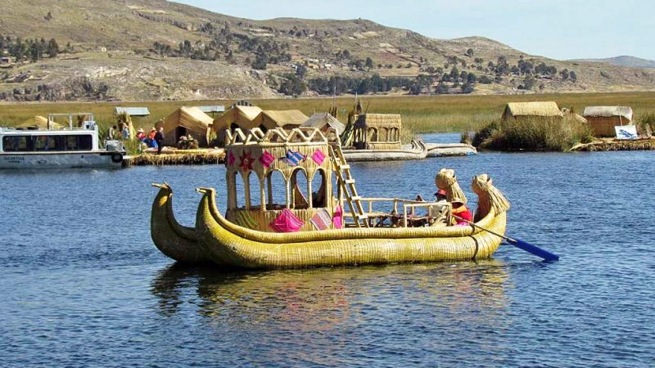
Early navigation of Lake Titicaca begins with the Uros peoples, who have built the lake's floating islands and lived on them for the past roughly 600 years. To this date, the Uros use crafty reed-woven vessels to navigate the lake for communication and trade (Fig. 10).
Fig. 10 A reed-woven vessel usd by the Uros peoples to navigate Lake Titicaca.
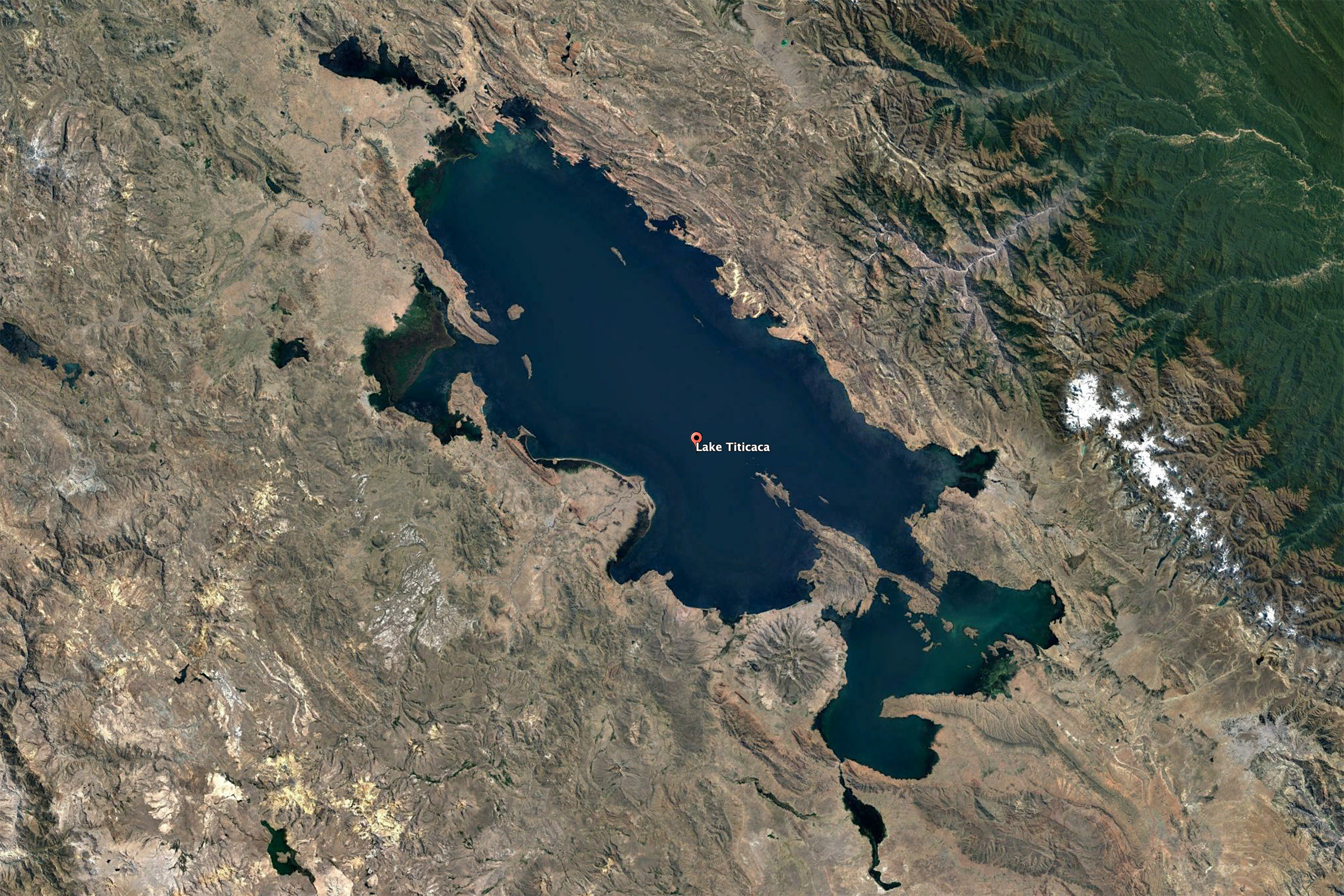
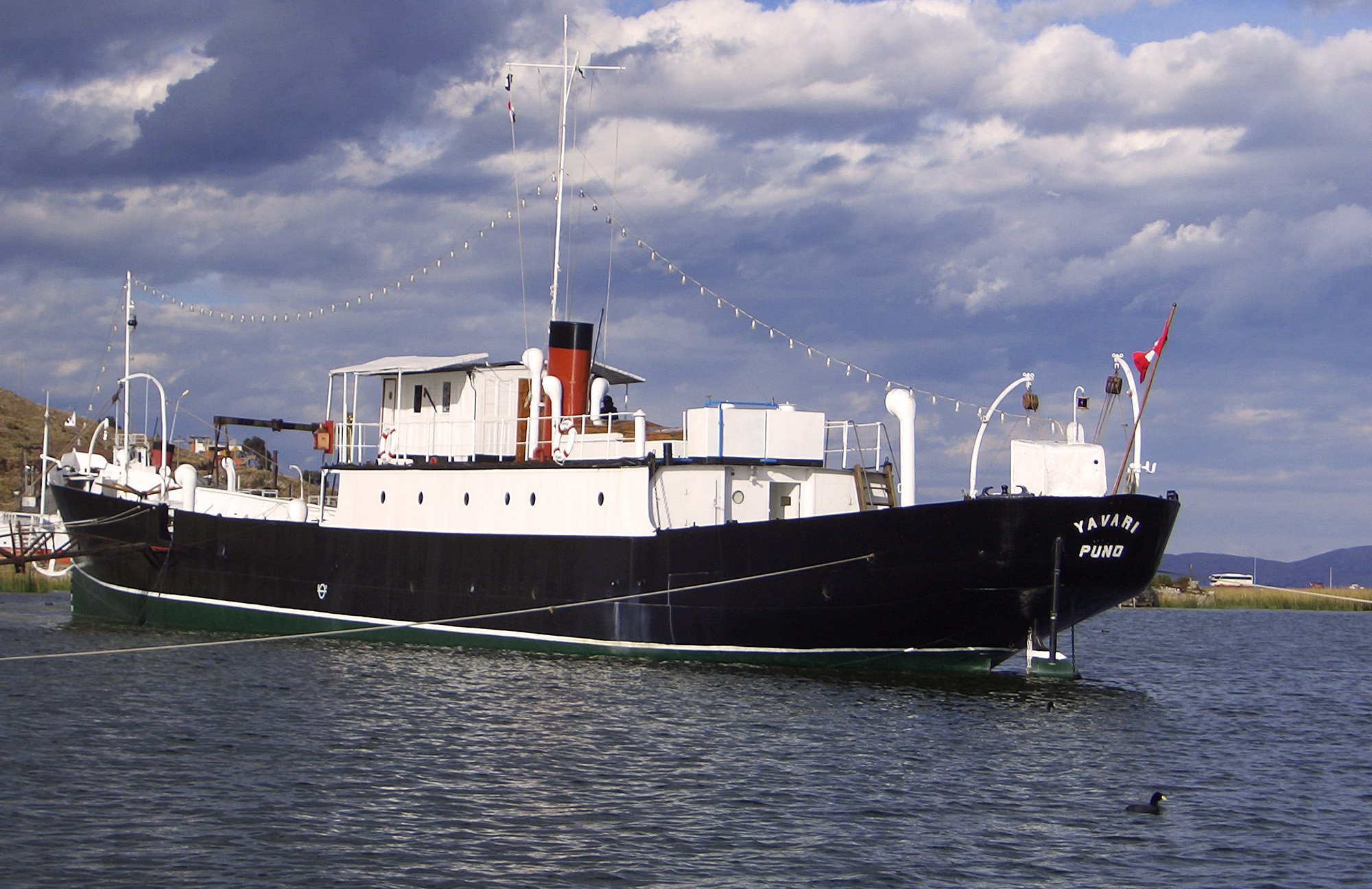
At 3810 m elevation above mean sea level, Lake Titicaca is the highest navigable lake in the world.
The first contemporary vessels were the Yavari and Yapura steamships,
built in England
in 1862 by orders of Ramon Castilla, the Peruvian president of the time.
The ship components, consisting of 2766 pieces, each weighing not more than
178 kilograms (what a mule could carry),
were transported by sea to the port of Arica, then
by rail to the nearby city of Tacna, and finally, entirely
on the backs of animals, a distance of 350 km to the port
city of Puno, on the shores of Lake Titicaca.
Fig. 11 The Yavari, currently being operated as a museum,
on the shores of Lake Titicaca,
REFERENCES
Aquize Jaen, E. Lake Titikaka: The highest navigable lake in the world.
https://ponce.sdsu.edu/lake_titikaka.html
Roache, M. A., J. Bourges, J. Cortes, and R. Mattos. 1992.
Climatology and hydrology of the Lake Titicaca basin.
| |||||||||||||||||||||||||||||||||||||||||||||||||||||||||||||||||||||||||||||||||||||||||||||||||||||||||
| 200311 10:30 (PDT) |
| Documents in Portable Document Format (PDF) require Adobe Acrobat Reader 5.0 or higher to view; download Adobe Acrobat Reader. |