1. INTRODUCTION Groundwater basins in arid and semiarid regions are recharged by channel infiltration as streamflow passes through the ephemeral streams and washes. In many instances, channel infiltration can be a substantial component of the total recharge. The latter consists of the following: (1) horizontal recharge by groundwater inflow, (2) vertical recharge by land surface infiltration, and (3) vertical recharge by channel infiltration. The channel infiltration component of the total recharge is commonly referred to as "transmission losses" (Soil Conservation Service, 1985). In this paper, we use a catchment model capable of hydrograph generation and combination, nonlinear channel routing, and channel abstraction to calculate groundwater recarge by channel infiltraiton in El Barbon basin, in Baja California, Mexico. This basin is ideally suited to this endeavor for the following reasons:
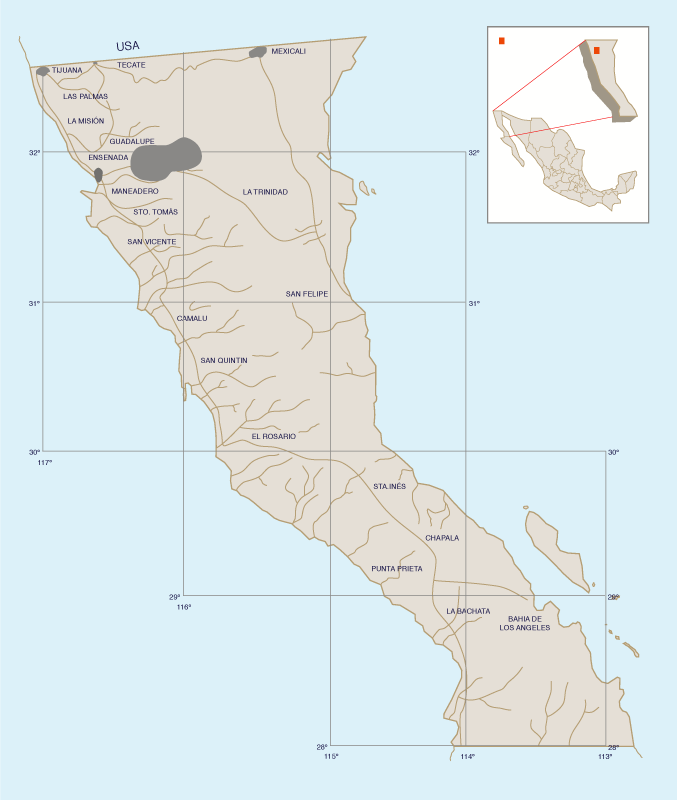
The objective of this study is to estimate, using distributed catchment modelling, the channel infiltration component of the total recharge for selected frequency-based storms ranging from 2-yr to 100-yr. It is hoped that once the magnitude of channel infiltration is recognized, it will encourage the conjunctive use of the basin's surface and groundwater resources. The Ojos Negros aquifer is currently subject to a mean overdraft of 0.32 m yr-1 (Beltran, 1997). If the overdraft continues, the agricultural activity in the valley could eventually be at risk. Therefore, it is necessary to search for alternative ways to augment the basin recharge, so that the irrigation demands may be met without incurring an overdraft. 2. THE OJOS NEGROS AND REAL DEL CASTILLO VIEJO VALLEYS The Ojos Negros and Real del Castillo Viejo are two neighboring valleys located in the state of Baja California, Mexico, approximately 40 km east of Ensenada (Fig. 1). They encompass an area of 165 km2 and are wholly contained within the basin of El Barbon Wash, which drains the Juarez Range (Sierra Juarez) to the East. The El Barbon basin lies between 31°51′ and 32°11′ North latitude, and 115°52′ and 116°23′ West longitude. The elevation varies between 1820 m in the headwaters and 590 m at the basin outlet.
El Barbon Wash originates in the vicinity of Laguna Hanson, which, at an elevation of 1620 m, is the only natural freshwater lake in Baja California. As it flows down the Juarez Range, the wash receives the contributions of several tributaries, among them, Los Barrancos and El Ranchito. Later, upon entering the Ojos Negros valley, it spreads out to a wide and shallow ephemeral sand-bed channel. After crossing the Ojos Negros and Real del Castillo Viejo valleys, for about 38 km, El Barbon Wash exits through a narrow gorge, which acts as a geologic control, at a distance of 3 km from Real del Castillo Viejo. At the gorge, the basin has a drainage area of 1094 km2. During infrequent storm events, a substantial portion of the surface runoff is abstracted by channel infiltration in these two valleys. The climate of El Barbon basin ranges from semiarid to arid, whereas that of the Ojos Negros and Real del Castillo Viejo valleys is predominantly arid. In the mountainous portions of the basin, mean annual precipitation is 475 mm, based on 15 yr of data at San Juan de Dios Norte (1970-84). In the lower valleys, mean annual precipitation is 250 mm, based on a 25-yr average at Ojos Negros (1970-94). The mean annual precipitation for El Barbon basin as a whole is estimated at about 440 mm, which amounts to an annual moisture supply of 480 × 106 m3.
The predominant vegetation in the basin is chaparral in the lower and intermediate elevations (600-1600 m) and evergreen pine forest in the higher elevations (1600-1800 m). The predominant land use is pasture, except in the valleys, where intensive agriculture is practiced. To this date, El Barbon basin remains ungaged. The mean annual runoff coefficient is estimated to be about 0.1, judging from data in neighboring basins of similar climatological, physiographic and vegetative features, which amounts to a mean annual runoff of 48 × 106 m3. However, this regional estimate could be substantially reduced if channel abstractions are deemed to be significant. 3. GROUNDWATER RESOURCES SUMMARY The groundwater basin of the Ojos Negros valley is bowl-shaped, filling a tectonic depression with an area of 113 km2. The aquifer proper, composed primarily of sands and gravels, has an area of 49.7 km2 (Beltran, 1997).
The water table elevation varies from 676 to 729 m. The aquifer thickness varies from The aquifer recharge is 18.6 × 10⁶ m3 yr-1, of which 12.2 × 10⁶ m3 yr-1 corresponds to horizontal recharge ( + ), 6.8 × 10⁶ m3 yr-1 to vertical recharge ( + ), and 0.4 × 10⁶ m3 yr-1 to horizontal discharge ( - ). The horizontal recharge and discharge is through subsurface flows; the vertical recharge consists of land surface and channel infiltration. The withdrawal by pumping has been measured to be 25.1 × 10⁶ m3 yr-1. Therefore, the overdraft amounts to 6.5 × 10⁶ m3 yr-1, equivalent to 0.32 m yr-1 (Beltran, 1997). 4. THE CATCHMENT MODEL The RAINFLO model was used to simulate selected rainfall-runoff events in El Barbon basin (Ponce et al., 1985). RAINFLO is a distributed event rainfall-runoff model which has the following significant features:
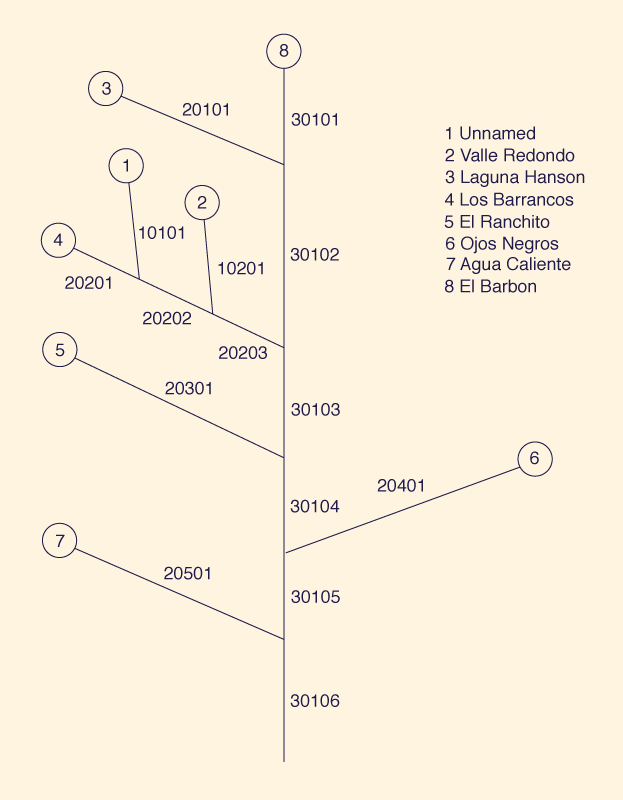
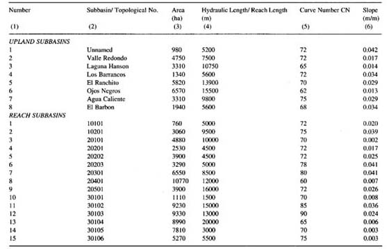
The significant features of the model used herein are: (1) its advanced topological structure, which enables hydrograph combination at network junctions, regardless of the network's complexity; These features make it particularly applicable to distributed catchment modelling in arid/semiarid basins such as the one considered here. 5. MODEL APPLICATION The first step in model application is to delineate the basin boundary, examine the stream network, and determine the set of topological numbers. Careful examination of the basin/stream network led to a choice of eight upland and fifteen reach subbasins. Subbasin areas, hydraulic lengths, reach lengths, and channel slopes were measured from 1 : 50 000 quadrangle maps. Curve numbers, representative channel cross sections, and Manning friction coefficients were determined based on field surveys. Manning coefficients were estimated between 0.025 and 0.06 in the stream channels, and 0.035 and 0.08 in the overbank areas. Figure 2 shows the stream network topology of El Barbon river basin. The five-digit numbers identify the reach subbasins. The first digit represents the channel order, the two middle digits represent the channel number, and the last two digits represent the reach number. El Barbon basin is of third order: there are two first-order channels, five second-order channels, and one third-order channel. In addition, there are three reaches in the second second-order channel, and six reaches in the third-order channel. The upland subbasins are identified by single digits and ordered by ascending topological number. Table 1 shows hydrological characteristics of upland and reach subbasins.
Precipitation data (10-, 25-, and 50-yr return period) was obtained from the official government literature (Secretaria de Comunicaciones y Transportes, 1990). A 4-hr storm duration was chosen to match the area of the basin. Storm depths for orther frequencies (2-, 50-, and 100-yr) were obtained by correlation with San Diego County (California) precipitation data (County of San Diego, 1985). Antecedent moisture condition (AMC) was varied between 2.0 and 3.0 as a function of return period (County of San Diego, 1985; Ponce, 1989).
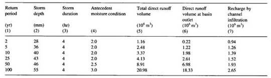
The channel infiltration velocity, used to calculate transmission losses, was chosen as 6. MODEL RESULTS Six runs were carried out with the RAINFLO model, varying the return period and corresponding storm depth. Table 2 shows the results of the computer simulations. Columns 1-4 show return period, storm depth, storm duration, and antecedent moisture condition, respectively. Column 5 shows the total direct runoff volume, calculated by integrating the flood hydrographs from upland and reach subbasins. Column 6 shows the direct runoff volume at the basin outlet, calculated by integrating the outflow hydrograph. Column 7 shows the groundwater recharge by channel infiltration, calculated by subtracting Column 6 from Column 5.
It is seen that event channel infiltration increases with return period, from 0.94 × 10⁶ m3 for a 2-yr flood to 2.65 × 10⁶ m3 for a 100-yr flood. That is, infrequent storm events from 2- to 100-yr return period are likely to recharge the groundwater in amounts varying from 14% to 39% of the mean annual vertical recharge of the Ojos Negros basin. These percentages correspond to 7. SUMMARY AND CONCLUSIONS
A distributed catchment model with the capability for both nonlinear channel routing
and channel abstraction is used to calculate groundwater recharge by channel
infiltration in El Barbon basin, in Baja California, Mexico. The basin drains
the Sierra Juarez Range to the East, and it comprises 1094 km2,
including the Ojos Negros and Real del Castillo Viejo valleys in its lower
reaches.
Thus, infrequent storms are substantial sources of groundwater
recharge in basins such as ACKNOWLEDGEMENTS The present study was performed in the Fall of 1997, while R.P. Pandey and S. Kumar were at San Diego State University, on leave from the National Institute of Hydrology, Roorkee, India. Their leave was funded by the United Nations Development Programme. REFERENCES
Beltran L. 1997. Actualizacion hidrogeologica del valle Ojos
Negros, Baja California (Hydrogeologic evaluation of the Ojos Negros valley, Baja California). Comision Nacional del Agua, Ensenada, Mexico (in Spanish).
Chow, V. T. 1959. Open-channel hydraulics. McGraw-Hill, New York.
Chow, V. T., D. R. Maidment, and L. W. Mays. 1988. Applied hydrology. McGraw-Hill, New York.
County of San Diego. 1985. Hydrology Manual, California.
Cunge, J. A. 1969. On the subject of a flood propagation computation method (Muskingum method). Journal of Hydraulic Research 7 (2), 205-230.
Matlock, W. G. 1965. The effect of silt-laden water on infiltration in alluvial channels. Ph.D. Thesis. University of Arizona, Tueson, Arizona.
Ponce, V. M. 1989. Engineering Hydrology, Principles and Practices, Prentice Hall, Englewood Cliffs, NJ.
Ponce, V. M., and V. Yevjevich. 1978. Muskingum-Cunge method with variable parameters. Journal of the Hydraulics Division, ASCE 104 (HY12), 1663-1667.
Ponce, V. M., Z. Osmolski, and D. Smutzer, D., 1985. Large basin deterministic hydrology: A case study. Journal of Hydraulic Engineering ASCE 111 (9), 1227-1245.
Secretaria de Comunicaciones y Transportes. 1990. Isohyetas de intensidad-duración-frecuencia, República Mexicana (Isohyets of intensity-duration-frequency, Mexico) (in Spanish).
Soil Conservation Service. 1985. National Engineering Handbook. Sectinon 4: Hydrology USDA Soil Conservation Service, Washington, DC.
|
| 211230 |
| Documents in Portable Document Format (PDF) require Adobe Acrobat Reader 5.0 or higher to view; download Adobe Acrobat Reader. |