Millions of years ago, during the Quaternary Period, the subsidence of strata formed a tectonic trough
that was covered with glacial water and precipitation.
Initially, the level of Lake Titicaca was 60 to 100 m higher
than today's level.
From a latitude of about 14°S, the Andes mountain range splits into western and eastern ranges,
forming an extensive flat and high region,
at elevations between 3700 and 4500 m above mean sea level,
These high plains, locally referred to as altiplanos,
give rise to the Northern, Central, and Southern high plains, which now
lie within territories of Peru, Bolivia, and Argentina.
Lake Titicaca, in southern
Peru and northern Bolivia, occupies the Northern High Plains;
Lake Poopo, in central Bolivia, occupies the Central High Plains;
and the salt flats of Coipasa and Uyuni, in Southern Bolivia, occupy the Southern High Plains.
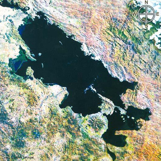
Lake Titicaca is a semiendorheic basin of 58 500 km2 of drainage area,
with the lake itself occupying a surface of 8500 km2 at the average
elevation of 3810 m above mean sea level.
The source of Lake Titicaca's water is split between direct precipitation and surface runoff
from several tributary streams and rivers. Direct precipitation accounts for 48% and surface runoff
for the remaining 52%. Table 1 lists the contribution of permanent rivers.
The average temperature of Lake Titicaca's water is 13°C, varying between
11°C in the winter and 13°C in the summer. The lake's large surface area and great depth, resulting
in a large volume of water, produces a thermal-regulating effect which is vital for the support of
local ecosystems.
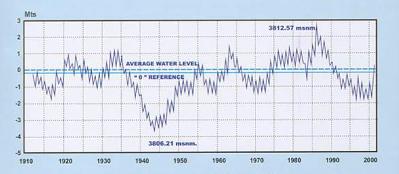
Lake Titicaca's geographic location, within the large endorheic Altiplano basin, makes it behave as a large raingage for local and regional precipitation. The water levels are measured at a metallic gage in the port of Puno, with the zero (0) level at 3809.09 m above mean sea level. The record of lake levels, measured on a daily basis since 1912, shows the maximum and minimum lake levels at 3812.57 m (April 1986), and 3806.21 (December 1943), respectively, indicating a total variation of 6.36 m. in the period of record (Fig. 1). Minimum lake levels occur at the end of the dry season (December), while maximum levels occur at the end of the wet season (April). The average water surface elevation is 3810 m and the average annual fluctuation in lake level is 0.8 m.
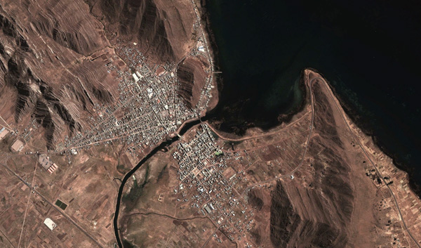
Lake Titicaca's inflow consists of direct precipitation and surface runoff. Of the total annual inflow, 95% is lost through evaporation, 3% percolates to the local aquifers, and the remaining 2% leaves the lake through the Desaguadero river. The latter is the lake's only outlet, with an average annual flow of 10 to 12 m3/s. However, it should be noted that there have been periods lasting days, months, or years, in which the Desaguadero river has reversed its normal course and flowed instead toward the lake. This has been the case when the lake level was either low, or when there had been strong or persistent precipitation in the Callacame and Maure rivers, which flow into the Desaguadero river near its beginning (headwater), at the lake's outlet (Fig. 2).
Lake Titicaca's drainage through the Desaguadero river is of sufficient quantity
to effectively reduce (by persistent flushing) the salinity of the lake to about 1000 ppm (mg/L),
which renders the lake
a freshwater lake.
The climate of Lake Titicaca and environs is cold and arid; cold due to the lake's high elevation, at slightly more than 3800 m, and semiarid because of the pronounced dry season (fall and winter) and wet season (spring and summer). The regional temperature fluctuates between a minimum of -1°C and a maximum of 15°C, with an average of 7°C. Directly above the lake, the temperature is a bit warmer, varying between 0°C and 16°C, with an average of 8°C.
Mean annual precipitation is 650 mm, spanning a rainy season typically lasting four months.
The geographical continental location of Lake Titicaca, next to the
hot and humid Amazon basin toward the east,
the dry coastal Pacific region toward the west,
and the frigid weather-driving Antarctic region toward the south,
renders the climate of the Lake Titicaca extremely varied.
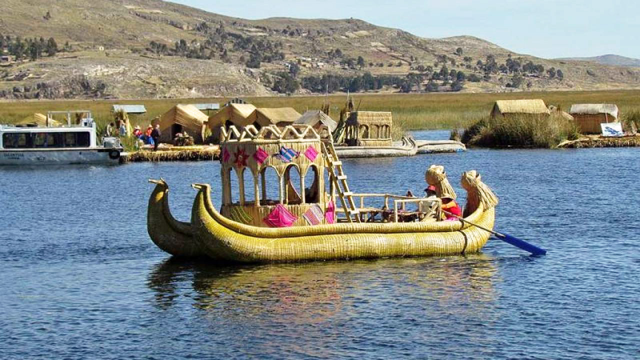
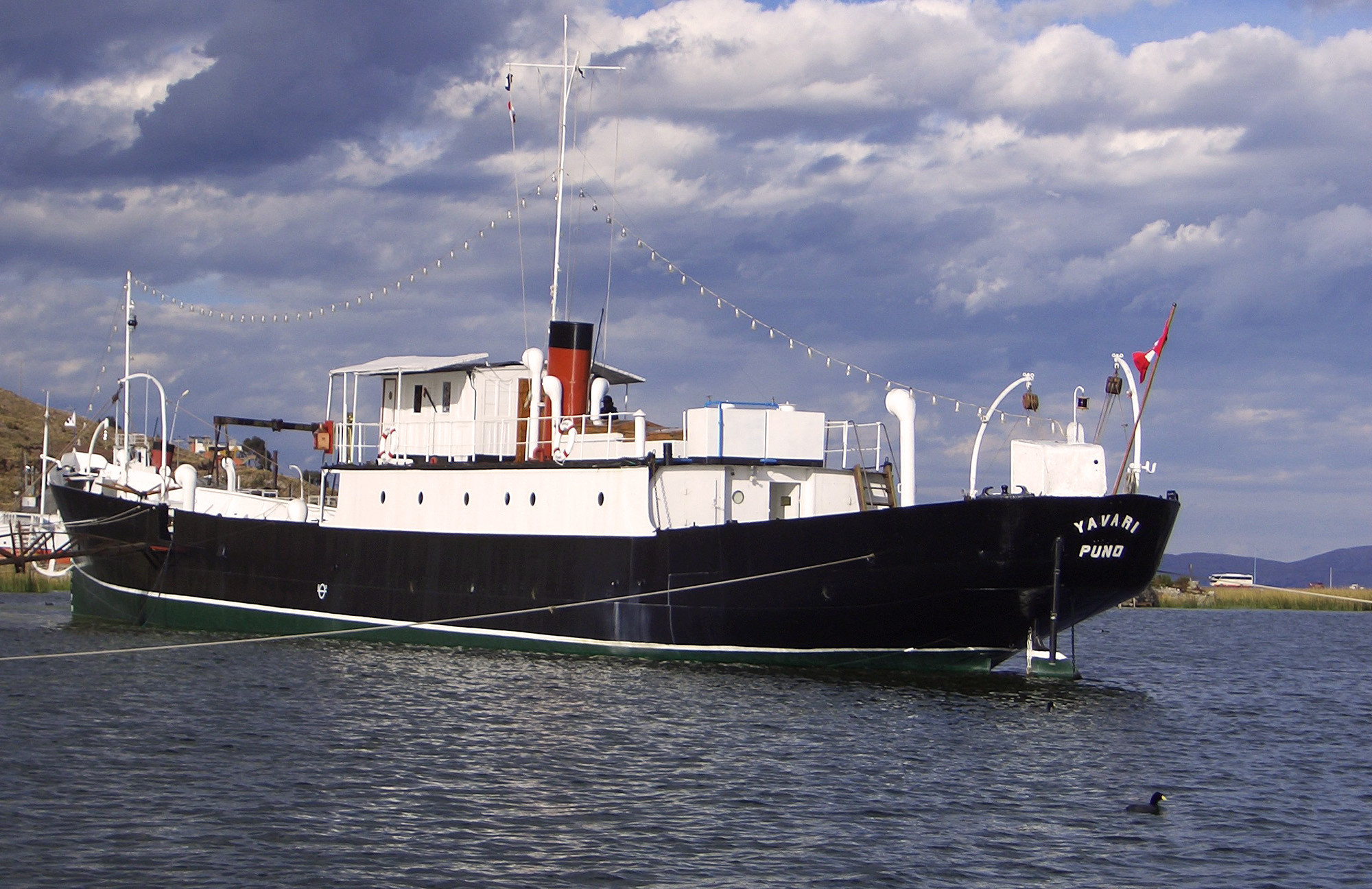
Early navigation of Lake Titicaca begins with the Uros peoples, which have inhabited the lake for more than 500 years. To this date, the Uros use reed rafts to navigate the lake for communication and trade (Fig. 3).
At 3810 m elevation above mean sea level, Lake Titicaca is the highest navigable lake in the world.
The first contemporary vessels were the Yavari and Yapura steamships,
built in England
in the 1860s by orders of Ramon Castilla, the Peruvian president of the time.
The ship components were transported by sea to the port of Arica, then
by rail to the nearby city of Tacna, and finally, entirely
on the backs of animals, a distance of 370 km to the city of Puno.
REFERENCES
Aquize Jaen, E. . Lake Titikaka: The highest navigable lake in the world.
https://ponce.sdsu.edu/lake_titikaka.html
| ||||||||||||||||||||||||||||||||||||||||||||||||||||||||||||||||||||
| 200309 02:00 (PDT) |
| Documents in Portable Document Format (PDF) require Adobe Acrobat Reader 5.0 or higher to view; download Adobe Acrobat Reader. |