1. INTRODUCTION
Baseflow augmentation refers to the temporary storage of subsurface water in
floodplains, streambanks, and/or stream bottoms during the wet season, either
by natural or artificial means, for later release during the dry season to
increase the magnitude and permanence of low flows.
The importance of streambank storage and its effect on stream hydrology,
ecology, and geomorphology is becoming increasingly apparent to a broad
spectrum of practitioners, including hydrologists, hydraulic and environmental
engineers, biologists, ecologists, and natural resource managers. The temporary
storage of precipitation in soils adjacent to streams, for later release during
the dry summer months, can directly benefit many stream uses and users. Among
the benefits of beseflow augmentation by streambank storage are:
An increase in the magnitude and duration of low flows to benefit diverse
downstream uses.
The maintenance of instream flows and water temperature, necessary for the
sustenance of adequate and diverse fish populations.
The development of a moist, year-round environment suitable for the
establishment and growth of riparian vegetation. This vegetation increases
channel and bank stability, decreases erosion and sediment transport, improves
water quality, enhances wildlife habitats, provides additional stream shading,
lowers stream temperatures, and improves stream aesthetics.
This paper presents a review of the subject of baseflow augmentation,
including theory and case studies. The aim is to focus the attention of
water and land resource managers on this timely subject.
2. HYDROLOGICAL ASPECTS
The flow of water and moisture under the land surface occurs under either unsaturated
or saturated conditions. The preferred path of movement of moisture in the unsaturated
zone is vertical, by percolation, toward the saturated zone; conversely, the preferred path of
movement of moisture in the saturated zone is horizontal, toward aquifer discharge areas
(Mull, 1986).
Sustainable low flows in streams are generally due to aquifer discharge.
Therefore, baseflow augmentation may result in the conversion of ephemeral and
intermittent streams into perennial streams. Ephemeral streams are usually influent,
serving as aquifer recharge areas; conversely, perennial streams are usually
effluent, serving as aquifer discharge areas. Intermittent streams can change their
character from effluent to influent, depending on the season.
Given the proper lithology and topography, it may be possible for unsaturated flow
to contribute to streamflow. However, sustained low flows appear to be possible
only in streams that remain effluent throughout the dry season. The following
conditions are required to assure that a stream remains effluent:
The draining aquifer should be
recharged seasonally with adequate amounts of moisture originating in natural
and/or artificial sources.
The water table should be shallow
enough to be intersected by the stream.
The aquifer's size and hydraulic
properties should be conducive to the maintenance of flows throughout the dry season.
These conditions are related. Generally speaking, adequate aquifer replenishment
leads to shallow groundwater tables; in turn, shallow water tables lead to
effluent, i.e., perennial streams.
Water that does not infiltrate may accumulate in surface depressions or,
as is more generally the case, become available for surface runoff.
In surface soils of low permeability, whether natural or human-induced,
increased surface runoff may lead to floods and flood damage.
Furthermore, increased surface runoff substantially enhances
the capacity of the flow to entrain and transport sediment,
resulting in reservoir sediment deposition and decreased water quality.
While aquifer replenishment is subject to management, the hydraulic properties
of aquifers are largely determined by nature. Therefore, it is possible
to accomplish baseflow augmentation by increasing seasonal aquifer replenishment.
Moreover, the aquifer's size and hydraulic properties can be used
to identify those aquifers which can be readily managed for
baseflow augmentation.
3. HYDRAULIC ASPECTS
Given adequate aquifer replenishment, baseflow augmentation hinges upon the
characteristics of the aquifer, including its geometric features and hydraulic
properties. The aquifer's geometric features determine its type, size,
and boundaries. The hydraulic properties help establish the rate of drainage,
which in turn determines whether or not the aquifer can continue to drain throughout the summer.
The rate of baseflow recession is determined by the interaction between surface and subsurface flow near streambanks. Drainage of finite-width aquifers to completely penetrating
streams follows an exponential decay curve (Cooper and Rorabaugh, 1963):
For practical applications, the recession constant α can be obtained from Eq. 1 using baseflow recession data. Moreover, given an estimate of aquifer width L, coefficient of storage S, and transmissivity T, Eq. 2 can be used to solve for the recession constant α. With the aquifer parameters either known, estimated, or obtained by calibration using streamflow data, Eq. 1 can be used in a predictive mode to calculate baseflow recession curves.
4. VEGETATIVE ASPECTS
The vegetative aspects of baseflow augmentation are now beginning to receive wide attention. This has closely followed renewed public interest in riparian areas, their hydrology, ecology, and management. Riparian areas are the usually narrow strips of land that border creeks, rivers, and other bodies of water. Riparian areas generally support a great diversity of riparian vegetation. In semiarid regions, the riparian vegetation is typically phreatophytes, or well plants, i.e., plants that are able to survive the dry summer months by drawing moisture from the subsurface and groundwater (Meinzer, 1927).
Up to the early 1970s, phreatophytes were largely regarded as a nuisance, consuming large amounts of valuable water, particularly in the semiarid western United States. The last decade, however, has seen a gradual change in the role of riparian areas (U.S. General Accounting Office, 1988). Riparian areas are now broadly perceived as beneficial, positively impacting a wide range of stream functions, including water and sediment control, channel and streambank stability, fish and wildlife habitat, stream temperature, water quality, and stream aesthetics. Riparian areas help store large amounts of water in streambanks and stream bottoms, with the vegetation consuming only a fraction of the increased storage. The amount of water consumed by riparian vegetation is seen as a small price to pay for the multiple benefits that can accrue from healthy riparian areas.
The relationship between streamflow augmentation and riparian vegetation is unclear at this time, despite the many efforts to document the link between them (Heede, 1977; Stabler, 1985; Elmore and Beschta, 1987). A plausible scenario appears to be the following: increased amounts of subsurface moisture in streambanks, resulting from natural and/or artificial aquifer replenishment, encourage the establishment and growth of riparian vegetation and assure its survival from year to year. In turn, the riparian vegetation increases sediment deposition, soil infiltrability, soil-moisture retention capacity, and reduces stream velocities, further increasing the rate of subsurface moisture replenishment during high flows. Increased subsurface moisture replenishment then leads to saturated groundwater flow and to groundwater accretion and raises the water table near the streambank. With an aquifer of the proper geometric and hydraulic properties, the rise of the water table near the streambanks can change the character of the adjoining stream from intermittent to perennial. Moreover, the magnitude and duration of summer streamflows is a function of the aquifer
properties and of the effectiveness and amount of aquifer replenishment.
5. CASE STUDIES OF BASEFLOW AUGMENTATION
Four case studies of baseflow augmentation are reviewed here: (1) Camp Creek, Oregon; (2) Sheep Creek Barrier Dam, Utah; (3) Alkali Creek, Colorado; and (4) Trout Creek, Colorado.
Camp Creek, Oregon
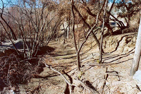
The experience of Camp Creek is regarded as a classical example of successful baseflow augmentation following sound riparian management (Elmore and Beschta, 1987). Camp Creek, a tributary of the Crooked River, is located about 43 km east of Prineville Reservoir in Crook County, in semiarid central Oregon. It is about 64 km in length, including its south, middle, and west forks. Before extensive settlement in the mid-nineteenth century, the area drained by Camp Creek was a grassy wetland, featuring predominantly grassy vegetation and a shallow water table maintained within root reach throughout the year. The grassy vegetation encouraged soil infiltrability and made possible an effective aquifer replenishment from year to year. Around the turn of the century, overgrazing of the meadow (loss of grassy vegetation coupled with reduced surface soil infiltrability caused by livestock trampling) led to increased quantities of surface runoff and incipient gully development. Under these conditions, severe floods triggered accelerated gully erosion and led to the development of the deeply incised channel with almost vertical banks which now cuts through the valley. Winegar (1977) has documented gully depths ranging from 4.5 to 7.5 m and widths from 7.5 to 30 m.
In time, the inadequate aquifer replenishment led to the draining of the meadow and the lowering of the water table to the point where it remained permanently out of reach of most herbaceous vegetative species. Over a period of several decades, this unfortunate sequence of events led to the transformation of the Camp Creek meadow from a grassy wetland into an area that could support only dryland species, with sagebrush taking over as the predominant type of vegetation. The Camp Creek meadow and its environs, which originally provided a livelihood for approximately 75 people, is now only able to support only one family (Wayne Elmore, personal communication).
About 20 years ago, the Oregon Department of Fish and Wildlife and the U.S. Department of the Interior's Bureau of Land Management took bold steps to reverse the desertification of the Camp Creek Valley. Beginning about 1968, increasing lengths of Camp Creek (up to approximately 6 km) were fenced to exclude livestock, with fencing continuing to date (1990). Over the years since the original fencing, the exclusion of livestock has allowed the establishment of a healthy riparian area. This has led to a buildup of the streambed and streambanks, a deeper and more stable low flow channel, and a reduction in the amount of sediment being transported by the stream. Net aggradation of the streambed is continuing to date.
A byproduct of the Camp Creek fencing has been the substantial increase in summer flows within the exclosure. Despite recent field research to document the groundwater system at Camp Creek (Barber, 1988), the mechanisms responsible for this phenomenon have not been clearly examined. The presence of the exclosure, resulting in the establishment of riparian vegetation, net bank building, channel aggradation, and subsequent changes in stream gradient above and within the exclosure, may be responsible for raising the water table and decreasing the exit gradient to the stream, thereby slowing the rate of aquifer drainage into the creek.
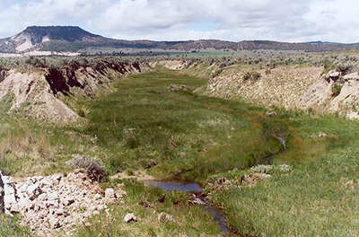
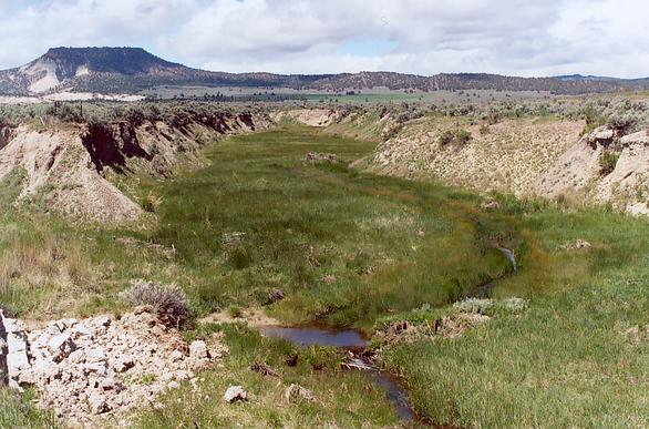
Detail of Camp Creek (photo 1989).
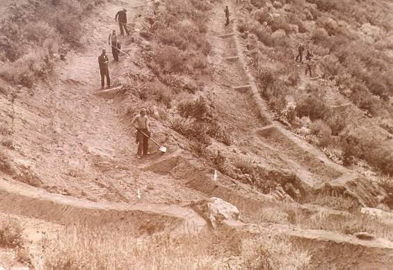
Detail of Camp Creek (photo 2004). Sheep Creek Barrier Dam, Utah The Sheep Creek Resource Conservation Area Project was implemented from 1957 to 1966 to stabilize and rehabilitate the upper watershed of Sheep Creek, a tributary of the Paria River, in southwestern Utah. The Sheep Creek project was a cooperative effort involving six federal agencies, the Utah Division of Wildlife Resources, and private landowners. Rehabilitation and stabilization measures included construction of detention dams, dike water-spreader systems, gully plugs and check dams. In addition, numerous seeding and brush control projects were undertaken, and grazing management was intensified (Hooper et al., 1987).
As part of the project, the Bureau of Reclamation constructed
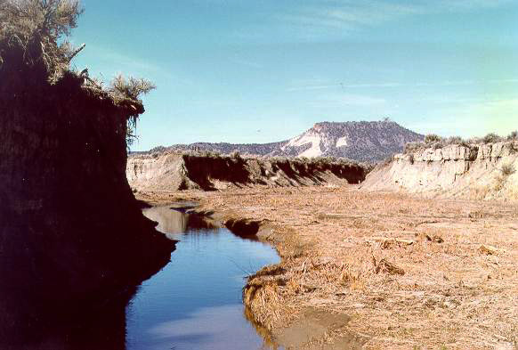
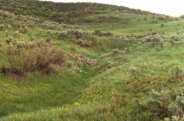
Sheep Creek Barrier Dam, a large detention dam on the main stem of Sheep Creek at the lower end of the project area. This dam has been very successful in trapping sediment eroded from gullies and other headwater sources. Healthy stands of riparian vegetation have become established on approximately 6.6 ha of surface area above the sediment deposit. A small channel, with an average bankfull capacity of 2.6 m3/s, is currently incised in the sediment wedge that has formed between the spillway and the upstream natural channel. A perennial flow at the dam has resulted from water draining slowly from the accumulated sediment deposit. Flooding occurs on the sediment wedge for all significant runoff events. Flooding serves to spread the flows laterally and reduce runoff peaks. In addition, flooding reduces stream energy, encourages sediment deposition, and recharges the aquifer. The size and recharge characteristics of the sediment wedge at Sheep Creek Barrier Dam are apparently adequate to maintain perennial flow at the dam site.
Sheep Creek flowing into Barrier Dam, showing perennial flow (photo 1989). Alkali Creek, Colorado Alkali Creek is located in the White River National Forest, 32 km south of Silt, Colorado. In 1958, the Alkali Creek Soil and Water Rehabilitation Project was initiated by the USDA Forest Service in response to increased land use pressure, as shown by accelerated gully development throughout the first half of the twentieth century. The gully growth is attributed to the combined effect of drought and overgrazing, as well as the overuse of the agricultural lands below the watershed. Overuse of the lands led to greater incision of the channels, which resulted in the lowering of the base level for Alkali Creek (Heede, 1977). The headwaters of Alkali Creek, about 2.5 square kilometers in area, were fenced from 1958 to 1966 to exclude cattle grazing. In 1963, the Forest Service constructed 133 check dams in about half of the gullies located within the project area. Four gullies with a total length of 580 m were converted to vegetation-lined waterways. Seven years later, the previously ephemeral flow became perennial, although there was no noticeable change in average annual precipitation during the period. The change from ephemeral to perennial flow at Alkali Creek is attributed to the establishment of vegetation in the gullies above the check dams.
The vegetated channels and check dams were able to moderate flow velocities, arrest gully erosion, and encourage sediment deposition. In time, the sediment deposits behind the check dams acted as artificial aquifers, retaining flood waters and creating a sufficiently moist environment to encourage the growth of riparian vegetation. Once established, the riparian vegetation aided aquifer replenishment by reducing flow velocities, trapping sediment, and increasing soil infiltrability.
Two of the 133 check dams built by the U.S. Forest Service in the Alkali Creek watershed (photo 1989). Trout Creek, Colorado
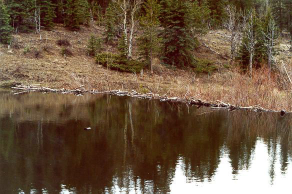
The Trout Creek watershed is located within the San Isabel National Forest, east of Buena Vista, Colorado. Following settlement in the mid-nineteenth century, the Trout Creek watershed was subjected to intensive exploitation for timber, ranching, and farming. Timber clearing, overgrazing, and numerous forest fires stripped the watershed of its natural vegetation, encouraged accelerated erosion, and led to the development of an extensive gully network. In 1933, the Trout Creek Civilian Conservation Corps was established to carry out watershed rehabilitation works in Trout Creek.
A large beaver dam in the Trout Creek watershed (photo 1989).
6. MANAGEMENT STRATEGIES FOR BASEFLOW AUGMENTATION Several strategies for baseflow augmentation have been proposed in the literature. Invariably, they focus on the replenishment of subsurface water and groundwater during the wet season, for later release during the dry season. Specific amounts of baseflow recovery will depend on the size and hydraulic properties of the aquifer, as well as on the intensity of management. Management strategies for baseflow augmentation fall under the following five categories: (1) range management, (2) upland vegetation management, (3) riparian vegetation management, (4) upland runoff detention and retention, and (5) the use of instream structures. Range Management The objective of range management is to optimize the use of range resources through manipulation of the range ecosystem. Benefits from range management include livestock grazing, soil and water conservation, enhanced wildlife habitat, improved recreation, and enhanced aesthetics.
The hydrological effects of livestock grazing have been recognized for several decades
The net effect of poorly managed livestock grazing is increased surface runoff and erosion and a decreased rate of subsurface moisture replenishment. Throughout the years, numerous studies have shown that uncontrolled grazing of livestock in the semiarid western United States has a pronounced effect on soil and water conservation. However, prohibiting or substantially limiting livestock grazing on western public rangelands does not appear to be a politically feasible solution at this time. Barring grazing exclusion, range management is currently seen as a viable alternative. Range management aims to control the intensity, duration, and season of use of vegetation by livestock. A range management plan prescribes rotational grazing strategies that control the distribution of livestock to meet management objectives. If given the option, livestock will tend to concentrate in riparian areas; therefore, these areas often become overutilized, while forage on adjacent uplands remains underutilized. Range management systems are designed to more evenly distribute grazing pressure, to improve rangelands and to ensure the sustainability of renewable resources. The exclusion of livestock from some of the nation's arid and steep rangelands may be a desirable and viable option. However, extreme solutions such as heavy continuous grazing or complete grazing exclusion do not appear to be realistic management objectives. Programs of field research and demonstration are needed to establish the hydrologic impacts of specialized grazing systems, including: (1) the effect of grazing intensity or stocking rate (light, moderate, or heavy); (2) deferred, rotation, rest-rotation, and deferred-rotation grazing systems; and (3) grazing strategies for stream-riparian habitats. These studies would help identify the grazing practices best suited to a given site, of known climate, vegetation, soil, and topographic relief.
Sound range management is a viable management strategy for baseflow augmentation. Upland Vegetation Management The effects of upland vegetation management on baseflow augmentation are not very well defined to date. Past emphasis has been largely on the effects of vegetation clearing (forest and shrub) on water yield, rather than on baseflow augmentation. Numerous studies have attempted to relate vegetation clearing to water yield increases, with mixed results. For instance, Hibbert (1971) showed that under favorable conditions, water yield can be increased by conversion of chaparral to grass in Arizona. The amount of increase depends on the soil depth and moisture storage capacity, depth and distribution of annual rainfall, and types of vegetation present on the site before and after conversion. However, other studies have failed to establish a direct relationship between the clearing of certain types of forest vegetation (i.e., pinyon and juniper) and overall increases in water yield (Collings and Myrick, 1966). Baker (1984) studied a herbicide-treated pinyon-juniper watershed in Arizona and concluded that the increase in water yield brought about by the treatment was not significant. Bosch and Hewlett (1982) reviewed 94 catchment experiments designed to relate vegetation clearing to water yield and concluded that, while detailed quantitative relationships were elusive, it is possible to develop reasonable qualitative estimates for planning purposes. In general, vegetation clearing solely for the purpose of increasing water yield appears to be misdirected, since it is very likely to lead to increased erosion potential and to negatively impact water quality. There are, however, exceptions, particularly when the emphasis is shifted from water yield to baseflow augmentation. For instance, in central Oregon, juniper stands in their natural state are known to consume large amounts of water and to inhibit the growth of grassy vegetation, encouraging surface runoff and erosion. Partial clearing of these forests to allow the reestablishment of grassy vegetation leads to increased infiltration, reduced surface runoff and erosion, adequate soil moisture replenishment, and baseflow augmentation in nearby creeks (Wayne Elmore, personal communication).
Stabler (1985) has provided additional details on the central Oregon experience in baseflow augmentation. Streamflow increases were documented in five small Oregon watersheds that had undergone treatment by juniper cutting. Livestock were excluded from the treated watersheds. The limited experience with baseflow augmentation by upland vegetation management precludes broad generalizations. However, the central Oregon experience appears to hold some promise. More research is needed to clearly delineate the potential for baseflow augmentation as a result of upland vegetation management. The relationship between climate, topography, vegetation type, soil, surface and subsurface water amounts has a bearing on the potential for baseflow augmentation in a given upland site. Riparian Vegetation Management
The literature provides ample evidence in support of the statement that baseflow augmentation in small upland streams is directly related to the enhancement of riparian vegetation.
Dense growth of riparian vegetation has run counter to flood control objectives in natural channels draining large basins. These channels have tended to overflow their banks during floods due to the presence of riparian vegetation, which reduces stream conveyance, increasing the magnitude and frequency of floods. Where such floods have occurred, state and federal flood control officials have been requested to clear the flood channels of the riparian vegetation, to allow for the passage of flood waters. However, plans for clearing riparian vegetation to satisfy flood control objectives have been opposed by efforts to preserve the riparian habitat (Graf, 1980).
The multiple benefits of riparian vegetation to the hydrology and ecology of upland streams appear beyond doubt. However, for lowland streams, the issue of preservation of riparian vegetation versus flood control objectives is very complex, with hydrological, ecological, and legal implications. Upland Runoff Detention and Retention The positive effects of upland runoff detention and retention on the conservation of soil and water, the replenishment of subsurface and ground water, and the stabilization of streamflows (i.e., reduction of peak flows and increase in baseflows) have been recognized for some time. In general, replenishment of subsurface water and ground water is a necessary condition for baseflow augmentation. Therefore, upland runoff detention and retention is a viable management strategy to increase the magnitude and permanence of low flows. Horton (1937) has identified the following strategies for streamflow stabilization, i.e., baseflow augmentation: (1) an increase in the infiltration capacity of the soil, (2) an increase in depression storage, (3) a decrease in the rate of overland flow, and (4) the use of grasses.
In agricultural lands, substantial increases in infiltration capacity can be attained by keeping the soil in good tilth and cultivating promptly when the soil surface has become rain-packed or sun-baked. Increases in depression storage serve to moderate runoff, to lengthen the ponding time of surface water, to increase total infiltration, and to replenish subsurface moisture. Depression storage can be effectively increased by the construction of water-spreader dikes, which detain runoff in slopes and meadows, encouraging its infiltration into the soil. Such dikes have been used for centuries by agricultural societies throughout the world for the purpose of conserving water, particularly in semiarid regions. Oosterbann (1982), for instance, decribes the Kushkaba and Sailaba systems used in Baluchistan, Pakistan. The Kushkaba consists of a series of small earth embankments constructed across upland slopes for water harvesting purposes. The Sailaba system is similar in principle to the Kushkaba, but it is built on the flood plain, to retain overbank flood waters and encourage infiltration. In addition to dike structures, it is also possible to increase depression storage by agricultural practices such as strip cropping and contour furrowing.
Decreases in the rate of overland flow can be accomplished by increasing surface roughness, decreasing surface slope, and/or increasing the length of overland flow. Decreases in overland flow serve to slow down the rate of water exit from soil surfaces, increasing time of ponding and total infiltration. In natural vegetated slopes, increases in surface roughness are invariably related to the establishment and growth of grassy vegetation, which acts to impede overland flow, reducing its velocity. Decreases in surface slope can be accomplished through terracing. The use of grasses serves to reduce surface runoff as compared with areas under cultivation. Grasses provide a higher and better-sustained soil infiltration capacity. This is due to root, earthworm, and insect borings, and to the prevention of soil inwashing by the grass mat. Another, and probably more important reason for the observed low surface runoff from grass-covered areas is the greatly increased resistance to overland flow. The additional friction due to subdivision of the flow by plant stems and leaves lengthens overland flow detention time and increases total infiltration. Agricultural practices and other mechanical measures have long been identified as viable management strategies to conserve soil and water. Certain cropping practices and mechanical measures effectively reduce soil and water loss from croplands and other areas larking adequate protective cover. The U.S. Department of Agriculture (1940) has identified the following practices for the proper management of soil and water conservation: (1) crop rotation, (2) strip cropping, (3) terracing, (4) contour furrowing, and (5) the use of upland structures. Use of Instream Structures Baseflow augmentation can also be accomplished by the use of instream structures. An instream structure is broadly defined as any natural or manmade structure, either temporary or permanent, which has the effect of detaining and retaining strearnflows. By retaining flows, instream structures encourage local infiltration to streambed and streambanks, which contributes to subsurface and ground water replenishment. Therefore, instream structures can be effective means of augmenting baseflow (Heede, 1977; Van Haveren, 1986; DeBano and Heede, 1987). Natural instream structures are log steps and beaver dams. In small mountain streams bordered by forests, trees and logs falling across the channel create log steps, which act as check dams and influence the hydraulic geometry. Sediment accumulates upstream of the log steps, producing gentler channel gradients; in time, a waterfall develops over the log step. During high flows, the log steps are submerged, contributing to channel roughness and decreasing flow velocities.
Beaver dams can have some benefits for baseflow augmentation, but they are not without pitfalls. These dams change the hydraulic regime of a stream, decreasing flow velocities and encouraging the growth of riparian vegetation, which can aid in the replenishment of subsurface and ground water. They also raise water levels, increasing infiltration and moisture storage in streambed and streambanks, for eventual release as baseflow. Beaver colonies generally require an adequate renewable source of large organic material (such as willows) to build dams and dens, and to eat.
Manmade instream structures are either large dams, check dams, or trap dams. Large dams substantially impact all major stream functions and uses, including stream hydrology, sedimentology, ecology, biology, fisheries biology, and aquatic biota. In addition, large dams serve to moderate streamflows, decreasing the magnitude and frequency of floods and increasing the permanence of low flows. In time, this moderation of streamflows can have a significant impact on the morphology of downstream reaches. Among the long-term impacts of a large dam are: (1) the establishment and growth of riparian vegetation (Turner and Karpiscak, 1980); (2) increased bank stability;
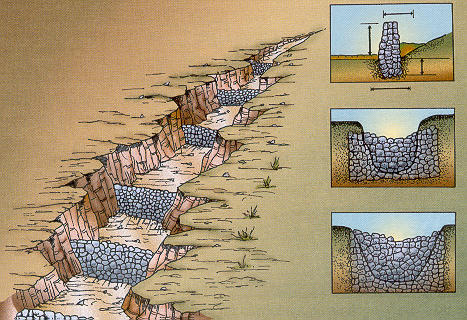
and Check dams are small structures built primarily for the purpose of adjusting the base level of badly degraded streams. These dams can be either temporary (log, brush, and brush-wire dams), more-or-less permanent (rock dams and gabions), or permanent concrete structures. Large numbers of check dams have been installed successfully in many western rangelands to detain and retain runoff, control accelerated gully erosion, revegetate creeks, and restore degraded watersheds to their original (pre-impact) condition (Jauch, 1957; Heede, 1977). The few documented eases of check dam failures underscore the importance of proper planning, siting, and building of check dams.
Trap dams are low instream structures designed to fill with coarse sediment over a period of several years following construction. The sediment deposited behind the dam serves as an artificial aquifer for the storage of flood waters and their eventual release as baseflow. Therefore, trap dams serve to moderate streamflow, augmenting baseflow for downstream uses (Bourne, 1984). The difference between check dams and trap dams is one of function. The primary function of check dams is to control base levels, and therefore, arrest channel downcutting and gully erosion. On the other hand, a trap dam is built primarily for the purpose of augmenting water supplies during the low flow season. The dam is carefully engineered and built to trap only coarse (sand and gravel size) sediment, enabling the formation of a saturated artificial aquifer and its functioning as early as the beginning of the second season after start of construction. Both check dams and trap dams can serve the purpose of augmenting boseflow.
7. RESEARCH NEEDS This review has shown that baseflow augmentation has been successfully accomplished in a few documented cases. Given its clear impact on soil and water conservation, particularly in the semiarid western United States, it appears that baseflow augmentation is a concept whose time has come. Research is needed on how to successfully integrate baseflow augmentation within comprehensive resource management strategies. Specific research needs are in the following areas:
The economic and legal aspects of baseflow augmentation will also need to be addressed if the concept is to be widely accepted in watershed management practice.
ACKNOWLEDGMENTS This paper is based on continuing research supported by Pacific Gas end Electric Company, Department of Research and Development, San Ramon, California. A 97-page PG&E R&D Report No.009.4-89.13, entitled "Baseflow Augmentation by Streambank Storage" can be obtained by contacting either of the authors.
LITERATURE CITED
Baker, Jr., M. B., 1984. Change in streamflow in a herbicide-treated pinyon-juniper watershed in Arizona. Water Resources Research, 20(11), 1639-1642.
Barber, J., 1988. Mapping of the groundwater system on Camp Creek using geophysical methods. M.S. thesis,
Department of Rangeland Resources, Oregon State University, Corvallis, Oregon.
Baurne, G., 1984. Trap dams: artificial subsurface storage of water. Water International, 9(1):2-9.
Blackburn, W. H., 1984. Impacts of grazing intensity and specialized grazing systems on watershed characteristics and Response. In: Developing Strategies for Rangeland Management, National Research Council / National Academy of Sciences, Westview Press, Boulder, Colorado, and London, England, pp. 927-983.
Bosch, J. M. and J. D. Hewlett, 1982. A review of catchment experiments to determine the effect of vegetation changes on water yield and evaportranspiration. Journal of Hydrology, 55:3-23.
Collings, M. R. and R. M. Myrick, 1966. Effects of juniper and pinyon erradication on streamflow from Corduroy Creek Basin, Arizona. U.S. Geological Survey Professional Paper 491-B.
Cooper, H. H. and M. I. Rorabaugh, 1963. Ground-water movements and bank storage due to flood stages in surface streams. U.S. Geological Survey Water Supply Paper 1536-J, U.S. Government Printing Office, Washington, D.C.
Copeland, O. L., 1960. Watershed Reetoration: A photo-record of conservation practices applied in the Wasatch mountains of Utah. Journal of Soil and Water Conservation, 15:105-120.
DeBano, L. F. and B. H. Heede, 1987. Enhancement of riparian ecosystems with channel structures.
Water Resources Bulletin, 23(3):463-470.
Elmore, W. and R. L Beschta, 1987. Riparian areas: Perceptions in management. Rangelands, 9(6):260-265.
Graf, W. L., 1980. Riparian management: A flood control perspective. Journal of Soil and Water
Conservation, 35(4):158-161.
Heede, B. H., 1977. Case study of a watershed rehabilitation project: Alkali creek, Colorado.
Research Paper RM-189, USDA Forest Service Rocky Mountain Forest and Range Experiment Station, Ft. Collins, Colorado.
Hibbert, A. R., 1971. Increase in streamflow after converting chaparral to grass.
Water Resources Research, 7(1):71-80.
Hooper, R., B. P. Van Haveren, and W. L. Jackson, 1987. The Sheep Creek Resource Conservation Area Project. Proceedings, XVIII Conference of the International Erosion Control Association, Reno, Nevada, February 26-27, pp. 117-126.
Horton, R. E., 1937. Hydrologic aspects of the problem of stabilizing streamflow.
Journal of Forestry, 35(11):1015-1027.
Jauch, J., 1957. A guide to watershed rehabilitation work as it pertains to the Trout Creek watershed. Internal document, USDA Forest Service San Isabel National Forest, Salida District, Salida, Colorado, January.
Lewis, G. L., 1984. Nebraska's shrinking platte river channel: hydrologic aspects and implications. Proceedings, American Society of Civil Engineers Hydraulics Division Specialty Conference, Coeur d'Alene, Idaho, pp. 639-643.
Meinzer, O. E., 1927. Plants as indicators of ground water. U.S. Geological Survey Water Supply Paper 577, U.S. Goverment Printing Office, Washington, D.C.
Mull. R., 1986. Low flow sustained by ground water. In: River flow modelling and forecasting (Chapter 4), D. A. Kraijenhoff and J. R. Moll (Editors), D. Reidel Publishing Company, Dordrecht, Holland.
Osterbann, R. J., 1982. Modern inferences in traditional water resources in Baluchistan. In: Annual Report,
International Institute for Land Reclamation and Improvement, Wageningen, The Netherlands, pp. 22-34.
Platts, W. S., 1988. Compatibility of livestock grazing With fisheries. In: Practical Approaches to Riparian Resource Management - An Educational Workshop, May 8-11, 1989, Billings, Montana.
Skovlin, J. M., 1884. Impacts of grazing on wetland and riparian habitat: A review of our knowledge. In: Developing Strategies for Rangeland Management, National Research Council/ National Academy of Sciences,
Westview Press, Boulder, Colorado, and London, England, pp. 1001-1113.
Smith. B. A.. 1981. Nebraska's shrinking Platte River channel: Biological aspects and implications. Proceedings, American Society of Civil Engineers, Hydraulics Division Specialty Conference, Coeur d'Alene, Idaho, pp. 634-898.
Stabler, F., 1996. Increading Summer Flows in Small Streams Through Management of Riparian
Areas and Adjacent Vegetation: A Synthesis. In: Riparian Ecosystems and Their Management:
Reconciling Conflicting Uses. Proceedings, First North American Riparian Conference, April 16-18,
Tucson, Arizona; also as General Technical Report RM-120, USDA Forest Service
Rocky Mountain Forest and Range Experiment Station, Ft. Collins. Colorado. pp. 206-210.
Turner, R. M. and M. M. Karpiscak, 1980. Recent vegetation change along the Colorado river between
Glen Canyon Dam and Lake Mead, Arizona, U.S. Geological Survey Professional Paper 1192.
U.S. Department of Agriculture, 1940. Influences of vegetation and watershed treatment on runoff, silting, and streamflow. A Progress Report on Research, Miscellaneous Publication No. 897, Washington, D.C.
U.S. General Accounting Office, 1988. Public Rangelands: Some Riparian areas restored but
widespread improvement will be slow. Report to Congressional Requesters, GAO/RCED-88-105, Washington, D.C.
Van Haveren, B. P., 1988. Management of instream flows through runoff detention and retention.
Water Reeources Bulletin, 22(3), 399-404.
Van Haveren, D. P., W. L. Jackson, and G. C. Lusby, 1987. Sediment deposition behind Sheep Creek Barrier Dam, Southern Utah. Journal of Hydrology (New Zealand), 26(2), 185-196.
Winegar, H. H., 1877. Camp Creek channel fencing -- Plant, wildlife, soil and water response.
Rangeman's Journal, 4(10), 10-12.
|
| 211228 |
| Documents in Portable Document Format (PDF) require Adobe Acrobat Reader 5.0 or higher to view; download Adobe Acrobat Reader. |