1. INTRODUCTION
The Northeastern region of Brazil is home
to a large semiarid expanse referred to
locally as the sertão, or backland.
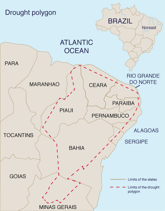
It encompasses about 900,000 km2 (347,000 mi2) in the
states of Bahia, Sergipe, Alagoas, Pernambuco, Paraíba, Rio Grande
do Norte, Ceará, Piauí, and Minas Gerais
A question that recurs in scientific, professional,
and political circles is how to effectively
manage the cycle of droughts and floods of the
Brazilian Northeast. In the aftermath of the
Great Drought of 1877-79, the Brazilian government
initiated a series of policies and strategies
to combat the droughts. These policies
were aimed at providing the means to store
water for use during extended periods of
drought. After more than a century of experience,
the time is now ripe for a reassessment of
these policies. The aim is to seek a more sustainable
solution to the cycle of droughts and floods in the sertão.
"Sustainable" implies a long-term solution, with benefits measured in
decades and even centuries, rather than
months and years. The answer is seen to lie in
the conservation of soil, water, nutrients, and
native vegetation, aimed at arresting the current
spiral of environmental desiccation. This
will eventually make possible the reversion to
nano-, micro-, and regional climates of lesser aridity.
2. THE DROUGHTS OF THE BRAZILIAN NORTHEAST: HISTORICAL PERSPECTIVE
In the 17th century, at least six droughts
were documented in the Brazilian Northeast:
1603, 1606, 1614, 1645, 1652, and 1692
(Guerra 1981; Rebouças and Marinho 1972).
In his classic work The drought of 1877-79, which killed more than 500,000 people, prompted the Brazilian government to formulate, for the first time, policies and strategies to combat the effects of the droughts. In 1881, a commission headed by the French engineer J. J. Revy studied several potential dam sites in Ceará, and in 1884 received authorization to start construction of the Cedro dam in Quixadá. In 1909, the Brazilian government established the Inspectoria de Obras Contra As Secas (Inspectorate of Public Works Against Droughts) or IOCS, and charged it with coordinating and unifying the government's actions within the drought polygon, and with developing a wide-range plan to combat the effects of the climatic irregularities. The first Director of IOCS, Miguel Arrojado Lisboa, commissioned scientific studies aimed at providing baseline information on the soil, water, and vegetation resources of the region. The studies of Lofgren and Luetzelburg on botany, and Crandall, Warring, Small, Sopper, and Moraes on geology and hydrogeology are still consulted to this date (Guerra 1981).
In 1919, a significant drought year, Public
Law No. 3965 announced a renewed effort by
the Brazilian government, with Epitácio Pessoa
as president, to combat droughts by authorizing
the construction of public works needed to irrigate
arable land in the Brazilian Northeast. In 1932, also a drought year, the Brazilian government authorized the construction of several public works in the affected region. The now Inspectoria Federal de Obras Contra As Secas (IFOCS) had the renewed charge to concentrate exclusively on the building of dams/reservoirs and irrigation works. Seventeen dams were completed within this period. In 1937, support for the effort dwindled again, as it became apparent that the drought was no longer an immediate problem (Guerra 1981). After the drought of 1958, the Departamento Nacional de Obras Contra Secas (DNOCS), the successor to IFOCS, initiated the construction of the great reservoirs of Orós, Banabuiú, and Araras. With the importance of surface reservoirs firmly established, DNOCS embarked on a program of small dam construction, entitled Açudagem em Cooperação (Cooperative Dam Building). The dams were to be built often on private land and with the cooperation of private citizens, and with federal support amounting to 50 to 70 percent of the cost of the project. In 1967, DNOCS established the program Engenharia Rural (Rural Engineering), which entailed the construction of small dams and reservoirs in upland regions, underground reservoirs, drilling of water wells, small irrigation works, and rural construction and electrification. The program, however, did not prosper, apparently due to the lack of enthusiasm shown by the regional offices charged with carrying out the works. It has been now largely replaced by the Projeto Sertanejo (Backlands Project). In addition to dam and reservoir building, the use of groundwater has been an effective tool to combat droughts in the sertão. In the neighboring state of Piauí, the existence of sedimentary deposits enables a water well production of 40,000 to 50,000 liters per hour. In many areas, just one well has made possible the livelihood of a small town. However, the same cannot be said for those wells drilled in the Cristalino, a metamorphic formation consisting of gneiss, schists, and amphibolites, which underlies most of the sertão. This water is of poor quality, rich in salts, and unfit for human consumption. Moreover, the production of these wells is small, amounting to only 2,000 to 3,000 liters per hour.
3. CURRENT SCENARIO For the past 100 years, combating droughts in the Brazilian Northeast has been accomplished primarily by providing surface water storage. Thc reliance on surface reservoirs has been referred to as the Açudagem policy. There is now a growing concern that the Açudagem policy may have focused on combating the effects, while for the most part brushing aside some of the underlying causes of the climatic irregularities. An all-encompassing study of the causes of droughts and floods in the Brazilian Northeastern region remains to be carried out. A first level of analysis is at the atmospheric mesoscale, which humans seem to be all but powerless to control. Ocean currents, wind circulation, and the El Niño effect have been generally ascribed varying responsibility for the climatic irregularities which befall the Brazilian Northeast. A second level of analysis is at the regional scale, which is largely of geomorphological origin. In the Brazilian Northeast, the coastal mountain ranges act as barriers to ocean moisture, effectively preventing large masses of moisture-laden air from entering inland regions. As with the mesoscale, humans appear to be powerless to control this regional scale component. A third level of analysis is at the microscale and its sequel, the nanoscale. The microscale is typically a second- to third-order catchment, while the nanoscale is a zero-order catchment, i.e., a small and distinct area of forest, pasture, or agricultural land. Historically, it is at these scales that humans have played a significant role as "climate changers" [see Denevan's (1966) classic account of how the Prehispanic Mojos Indians of the Eastern Bolivian plains managed to cope with adverse flood and drought conditions]. Through their actions spanning decades and centuries, humans have been able to alter the micro- and nanoclimates of the earth, for better or for worse. Unfortunately, they may have unwittingly contributed to the desiccation of the environment. This process of environmental degradation is now becoming all too clear, although the basic tenets have been recognized for quite a while.
In his Personal Narrative, the German scientist
Alexander von Humboldt (Humboldt and
Bonpland 1821) has keenly observed:
"When
forests are destroyed, the springs dry up entirely
or become less abundant. The river beds, remaining
dry during part of the year, arc converted
into torrents whenever great rains fall
onto the adjacent mountains. The sward and
moss disappearing with the brushwood from
the sides of the mountains, the waters falling in
rain are no longer impeded in their course; and
instead of slowly augmenting the levels of the
rivers by progressive filtration, they furrow during
heavy showers the sides of the hills, bear
down the loosened soil, and form those sudden
inundations that devastate the country. Hence
it results that the destruction of forests, the
want of permanent springs, and the occurrence
of floods, are three phenomena closely related together."
The currency of Humboldt's words and their
impact in a global context need no elaboration.
4. CLIMATE, VEGETATION, AND THE IMPACT OF HUMAN ACTIVITIES Paradoxically, the Brazilian Northeast, with its marked moisture gradients and diversity of microclimates, is a region particularly well suited to the study of the relationship between climate, vegetation, and human activities. Duque (1973) has suggested a classification of the various ecological regions of the drought polygon, in order of increasing moisture, into: (1) seridó, (2) sertão, (3) caatinga, (4) cariri velho, (5) curimatau, (6) carrasco, (7) cerrado, (8) serra, (9) agreste, and (10) mata. This classification embodies a spectrum of environmental moisture, indeed a "field laboratory" where judicious observation may reveal the interaction between climate and vegetation, and the extent of human influence.
Table 1 shows mean annual
rainfall and evaporation/rainfall ratios for several
ecological regions of the Brazilian Northeast.
This table shows that the evaporation/rainfall
ratio, a key climatic parameter, is a
function of type of vegetation, tending to decrease
with increasing environmental moisture,
as the vegetation changes from xerophytic to
mesophytic. In Duque's study (1973), evaporation
is interpreted as measured pan evaporation.
The German botanist Luetzelburg (1923) was able to document the relationship between climate, vegetation, and human activities in the sertão. He observed:
A close relationship exists between climate
and vegetation. The question is the extent to
which human activities can influence this relationship
at the various spatial and temporal
scales.
5. EVAPORATION VS. EVAPOTRANSPIRATION To understand the relationship between climate and vegetation, we examine the roles of evaporation and evapotranspiration in the context of the mesoscale and regional hydrologic balances. To provide a common ground, these and related terms are defined here:
In a terrestrial ecosystem, evaporation is produced from three sources:
In hydrologic practice, however, usage of the term "evaporation" is restricted to that of an aquatic ecosystem, i.e., a water body such as a lake, river, reservoir, or ocean. On the other hand, the term "evapotranspiration" refers to the total evaporation from a terrestrial ecosystem, which comprises:
6. GLOBAL AND REGIONAL HYDROLOGIC BALANCES
The Earth's land areas are divided into:
(1) endosed areas, which have no runoff; and
In regional context, the hydrologic balance is driven by the prevailing climate. In semiarid regions, the sum of evaporation and evapotranspiration is high relative to precipitation, on the order of 90 percent. Conversely, in humid regions, the sum of evaporation and evapotranspiration is likely to be about 50 percent (USDA 1940; L'vovich 1979). The comparison is more dramatic when it is recognized that a 10 percent runoff in a semiarid region may amount to only 50 mm yr1 (2 in yr1), while a 50 percent runoff in a humid region may reach 1,000 mm yr1 (40 in yr1). An exception to the aforementioned pattern is provided by the swamps and marshes, usually located in subhumid and humid regions, where the sum of evaporation and evapotranspiration is typically more than 90 percent of precipitation, with runoff being reduced to less than 10 percent. This is due to the small or negligible surface gradient, which acts to discourage runoff while encouraging evaporation and evapotranspiration. A routine hydrologic budget does not distinguish between evaporation and evapotranspiration proper, and often uses either term to refer to the combined process. Furthermore, the combined amount is considered a loss, at least as far as the terrestrial ecosystem is concerned. However, it is noted that the answer to the relationship between climate and vegetation lies in the fundamental distinction between evaporation and evapotranspiration. In semiarid regions, evaporation is the dominant process, with evapotranspiration being the actual evapotranspiration, which falls well below its potential value. Conversely, in humid regions, evapotranspiration is the dominant process, readily reaching its potential value, while evaporation is restricted to that of water bodies only. A hydrologic balance in a semiarid region, with 500 mm (20 in) of annual precipitation, may be as follows:
Conversely, the hydrologic balance in a humid region, with 2,000 mm (80 in) of annual precipitation, may be as follows:
The special case of a wetland maybe as follows:
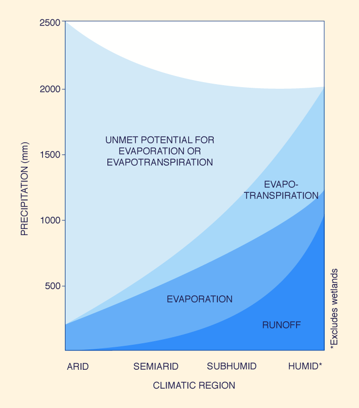
As shown in Table 1, the seridó, an arid ecosystem, has a high evaporation potential (evaporation/rainfall ratio in the range 2.5 to 5.8); therefore, little runoff. In this case, evaporation is high, while actual evapotranspiration from the sparse xerophytic vegetation is low. Conversely, the mata, a humid ecosystem, has a low evaporation potential (evaporation/rainfall ratio typically less than 1.0); therefore, substantial runoff. In this case, evaporation, mostly from water bodies, is low, while evapotranspiration from the dense mesophytic vegetation is high, readily reaching its potential value. Figure 2 shows a graphical interpretation of the components of the water balance for the range of climates experienced in the sertão, showing the unmet potential for evaporation or evapotranspiration. This unmet potential is substantial for arid and semiarid ecosystems, and close to zero for humid ecosystems. Thus, evapotranspiration and evaporation are seen to be quite different processes. Evapotranspiration is intrinsic to the development of the phytomass, while evaporation is not. Evapotranspiration is a result of life on this planet, while evaporation proceeds in the absence of life. Evapotranspiration enhances soil formation and preservation, while evaporation does not. Evapotranspiration results in the production of food and other biomass useful to animals, while evaporation does not. Evapotranspiration directly sustains life, while evaporation does not.
The albedo of vegetated surfaces, as well as that of water bodies, is lower than the albedo of nonvegetated surfaces. Thus, vegetated surfaces and water bodies are able to store more incoming short-wave energy, and to release it gradually as outgoing long-wave heat, particularly at night, where the long-wave heat dominates the radiation balance. This warming of the lower atmosphere causes air lifting, favoring the condensation of water vapor and the formation of rainfall (Balek 1983). Thus, the atmospheric moisture resulting from evapotranspiration and evaporation from water bodies has a tendency to condense and precipitate back, while that resulting from evaporation from nonvegetated surfaces does not. The denser and greener the vegetative surface, the more marked is the recirculation effect (Salati et al. 1978; Salati et al. 1979; Salati and Vose 1984). On the basis of the foregoing analysis, it is concluded that arid and semiarid ecosystems should be managed with the objective of maintaining or enhancing the ratio of evapotranspiration to evaporation. To the extent possible, this entails preserving native vegetation to achieve a balance between natural (forest and/or range) and human-induced ecosystems (agricultural and/or urban). An increase in this ratio, through conservation management, increases the biotic potential of the ecosystem, from which all forms of life ultimately benefit. Conversely, a decrease in this ratio, through deforestation, overgrazing, and other forms of land degradation, decreases the biotic potential of the ecosystem, eventually compromising all forms of life. It is seen that evapotranspiration and evaporation are quite different processes; thus, the justification for accounting for them separately, particularly in the management of water resources in arid and semiarid regions. It follows that human misuse of natural vegetation leads to the eventual replacement of evapotranspiration by evaporation, to an alteration of the nano-, micro-, and eventually even regional climates on a long-term basis, and to the gradual desiccation of the environment, typically from subhumid to semiarid, and from semiarid to arid. Arid and semiarid regions have irregular rainfall patterns that lead to recurrent droughts, often followed by destructive floods. Subhumid regions are less affected by droughts, while humid regions are almost free from them. In the Brazilian Northeast, the seridó is characterized by a rainfall regime having 8 dry months per year, and the caatinga 7 to 9 dry months per year. On the other hand, the mata has only 4 to 5 dry months per year (Duque 1973). This seasonal variability does not portray the whole picture, because the daily variability may be even more marked. Duque (1973) has concluded that a drought year in the sertão may be that year where it rains about half of the annual rainfall in just 1 month, and about half of that month's rainfall in just 1 day.
7. THE CASE FOR CONSERVATION MANAGEMENT In his studies of the sertão hydrology, Silva (1937) observed:
Thus, the objective of conservation management of an arid/semiarid ecosystem should be to preserve the ratio of evapotranspiration to evaporation. This entails the establishment of conservation policies, and the development of strategies and technologies to conserve water, soil, and nutrients. In regions already degraded by human activities, conservation management may take a more active role and be aimed at stopping and reverting the degradation process, eventually to return the degraded ecosystem to its former state of productive stability. The conservation of water, soil, and vegetation is a complex undertaking. Its Achilles heel is its distributed nature, i.e., the fact that it works better when it is extensively executed at the micro- and nanoscales. Historically, it is at these scales that humans have played a role as climate changers. Therefore, it follows that if humans, through their actions, can contribute to the desiccation of the climate, they can also, with renewed will, contribute to the humidification of the same. Thus, native vegetation must no longer be looked upon as merely a resource to be exploited, but also as nature's instrument for the regularization of the climate. In a societal context, the conservation of water, soil, and vegetation is based on federal, state, and local policies and laws and aimed at preserving a healthy balance between natural ecosystems and their human-induced counterparts, and to manage all with the overall objective of conservation. In a technological context, the conservation of water, soil, and vegetation is based on the following principles:
To summarize, an arid/semiarid ecosystem managed for conservation should preserve the ratio of evapotranspiration to evaporation. This entails putting in place the strategies and technologies to conserve water, soil, and nutrients. Can a terrestrial ecosystem be managed for conservation while at the same time increasing the availability of water resources for human use? The answer to this question remains elusive (Balek 1983). In the long term, the availability of more water for evapotranspiration results in the availability of more water for runoff, in a sort of multiplying effect resembling a cybernetic machine. This is due to the increased rate of soil creation, resulting in increased catchment wetting and increased replenishment of groundwater (L'vovich 1979; Ponce and Shetty 1995). In other words, the more water going to evapotranspiration, the more water there will be available for runoff in the long run. The converse bears repeating: The less water going to evapotranspiration, the less water there will be available for runoff. To elaborate on this point, we compare typical runoff coefficients for the arid/semiarid and subhumid/humid regions of the globe. Basins in arid/semiarid regions have runoff coefficients of 0.05 to 0.2, while basins in subhumid/humid regions have runoff coefficients of 0.3 to 0.5, and may be even highs in certain cases (L'vovich 1979). To give an example, the runoff coefficient of Riacho Feiticeiro, a tributary of the Jaguaribe river, in the heart of the sertão of Ceará, is 0.09. On the other hand, the runoff coefficient of the humid Amazon basin is 0.45 (Salati et al. 1979). Yet the evapotranspiration of humid regions greatly exceeds the actual evapotranspiration of arid regions. The culprit loss is seen to be not evapotranspiration, but rather the high evaporation from the nonvegetared surfaces which prevail in arid/semiarid regions. Thus, the case is made for the conservation of arid/semiarid terrestrial ecosystems as the preeminent tool of long-term climatic management.
8. CASE STUDY 1: THE AMAZON BASIN'S RAINFALL AND EVAPOTRANSPIRATION REGIME The Amazon river basin comprises an area of approximately 7,000,000 km2 (2.7 million mi2) in the central and eastern portions of South America, encompassing parts of Venezuela, Colombia, Ecuador, Peru, Bolivia, and Brazil. The region is s humid ecosystem comprising a tropical rainforest with an abundance of rainfall. Rainfall, however, is not evenly distributed in the basin. At Belém, Pará, close to the mouth of the Amazon river, mean annual rainfall is 2,600 mm (102 in). In the northwest, close to the Brazil-Colombia border, it attains a maximum of 3,600 mm (142 in). Yet toward the south, in the region transitional to the Brazilian shield, the mean annual isohyets are around 2,000 mm (79 in) (Sioli 1985). A characteristic of this huge humid terrestrial ecosystem is its rapid recirculation of moisture, from rainfall to evapotranspiration, and again to rainfall. Salati et al. (1978; 1979) and Salati and Vose (1984) have revealed that approximately 50 percent of the rainfall in the lower Amazon basin returns directly to the atmosphere, only to condense and fall again. In this way, differences in precipitation between wet and dry seasons are substantially attenuated, and the intensity of droughts and floods is diminished. It is clear, then, that the Amazon rainforest ecosystem influences its own climatic and rainfall regimes, and that at least in this case, more vegetation meths more evapotranspiration, and more evapotranspiration means more rainfall and certainly more runoff. It is noted that the Amazon river basin has a mean annual runoff estimated at 220,000 m3s-1 at its mouth (UNESCO 1978), amounting to roughly one-sixth of the total runoff contributed to the oceans by the Earth's landmasses.
9. CASE STUDY 2: THE UPPER PARAGUAY RIVER BASIN EVAPORATION/RAINFALL RATIOS The Upper Paraguay River basin comprises an area of 496,000 km2 (192,000 mi2) in southern central South America, 80 percent of which lies in Central Western Brazil (Mato Grosso and Mato Grosso do Sul) and the remaining 20 percent in eastern Bolivia. The basin is home to the Pantanal of Mato Grosso, the largest wetland in the world, encompassing 136,700km2 (52,800 mi2). The word "pantanal" means great swamp, implying that the region is subject to extensive and recurrent flooding. However, large portions of the Pantanal are flooded only during the annual crest of the Upper Paraguay River and its tributaries, and much nonflooded terra firma is interspersed throughout the region. The mixture of permanent swamp, seasonal swamp, and terra firma, as well as the contiguity of the Pantanal to four major South American ecosystems (the tropical Amazon rainforest to the north and northwest, the subhumid savanna woodlands of Central Brazil to the northeast, east, and southe, the humid Atlantic forest to the south, and the semiarid scrub forest of Eastern Bolivia and Western Paraguay to the west and southwest) has contributed to the richness and variety of its vegetation and fauna. The Upper Paraguay River basin features marked climatic gradients, from humid and subhumid in the uplands surrounding the Pantanal to the north, east, and south, to semiarid in the basin center lowlands. Mean annual precipitation varies from 1,800 mm (71 in) in the Chapada dos Parecis surrounding the Pantanal to the north, to 850 mm (33 in) at the mouth of the Taquari River in the basin center. Annual potential evapotranspiration varies from 1,300mm (51in) in Chapada dos Parecis to 1,400mm (55in) at the mouth of the Taquari River. Therefore, the evapotranspiration/ rainfall ratios are 0.72 for the Chapada dos Parecis, and 1.65 at the mouth of the Taquari River (Alfonsi and Camargo 1986; Alvarenga et al. 1984). It is seen that the humid upland regions surrounding the Pantanal have consistently low evapotranspiration/rainfall ratios (0.72), while the semiarid lowland region located in the basin center has a high evapotranspiration/rainfall ratio (1.65). The more mesophytic the vegetation, the less the potential (and actual) evapotranspiration, with evaporation reduced to that of water bodies only. Conversely, the more xerophytic the vegetation, the greater the potential evaporation, with evapotranspiration reduced to the actual evapotranspiration of the xerophytic plants.
10. CASE STUDY 3: SOIL AND WATER CONSERVATION WITH BRAZIL'S NATIONAL PROGRAM OF MICROBASINS In 1975, the government of the state of Paraná, Brazil, tied the awarding of agricultural credits to the execution of soil conservation works. The program, however, had limited success because the conservation works were performed using the farmer's property, not the encompassing watershed, as a unit of management. In this way, an individual farmer's conservation solution became his neighbor's or somebody else's problem. Gradually, is became apparent that this straregy was doomed to failure. Learning from this mistake, the focus of conservation management eventually shifted from each individual property to the microbasin as a whole, the latter encompassing a watershed of about 2.500 ha (6.175 ac). This led to the establishment, in 1987, of the Programa Nacional de Microbacias Hidrográficas (PNMH) (National Program of Microbasins). Among the specific objectives of PNMH are:
In Cruz Alta, Rio Grande do Sul, Brazil, the techniques of conservation management have been applied since 1985. One of the first conservation measures was the construction of terraces across property lines, with the fences eliminated. In this way, water retention was improved, with the land now able to soak up 100mm (4 in) of rainfall without appreciable runoff. Other applicable soil and water conservation measures were also implemented, and the success of the program did not wait to be announced. To date, the Programa Estadual de Microbacias Hidrográficas (State Program of Microbasins) of his Grande do Sul reaches 155 municipalities, comprising 315 microbasins, 12,000 families, and 294,000 ha (726,500 ac) of land. In addition to soil conservation, water was apparently also conserved, because the productivity of soy beans increased 54 percent, corn 85 percent, wheat 40 percent, and beans 74 percent (Globo Rural 1993). In the state of Paraná, the Sáo Roque microbasins, in the municipality of Realeza, close to the Argentine and Paraguayan borders, has been applying conservation measures for the past few years. The basin is located in steep and rocky terrain, not suited for agriculture in the absence of management. The renewed emphasis on soil and water conservation has now turned viable all the small rural properties of the region. The construction of terraces to hold on to the water and soil and the application of techniques such as soil decompaction, crop rotation, and green manure has doubled the productivity of the soil in just 2 to 3 years. Other examples, such as that of Tupãssi in western Paraná, show that conservation management works by improving water retention, while at the same time reducing erosion. Agricultural credits were tied to the construction of tcrraces, and farmer support quickly ensued. The land is now able to sustain 150 mm (6 in) of rainfall in a few hours, without surface runoff (Globo Rural 1993). The success of PNMH in the Brazilian South shows conclusively that conservation management can lead to the replacement of evaporation by evapotranspiration, even in the case of the human-induced agricultural ecosystems.
11. A BLUEPRINT FOR THE SERTÃO'S SURVIVAL
The case for conservation management having
been made, we now outline a comprehensive
strategy to manage the cycle of droughts
and floods in the semiarid Brazilian Northeast.
The keystone strategy is conservation management, without which the rest are eventually doomed to failure. Conservation management entails the conservation of the water, soil, and nutrient resources of the semiarid Brazilian Northeast, with the objective of preserving the ratio of evapotranspiration to evaporation. In practice, this means the formulation of policies and laws, and the implementation of strategies and technologies to conserve natural vegetation, and to retain water, soil, and nutrients. Agricultural practices should focus on the techniques of sustainable agriculture, without which soil, land, and environmental degradation soon set in. Duque (1949; 1964; 1973; 1982) pioneered the Lavouras Xerófilas, i.e., the practice of silviculture and agriculture using native vegetation, well adapted to the harsh climatic conditions in the sertão. Some of that xerophytic plants are able to survive drought conditions by accumulating reserves within their organisms, others by consuming relatively small amounts of water, and yet others by absorbing moisture from the atmosphere at night. The lavouras xerófilas are indeed "cashcrops" for export, as well as valuable raw materials suitable for diverse uses. Duque (1982) has observed: Duque (1964; 1982) points out the many advantages of xerophytic crops; they are:
The benefits of conservation management are a function of the scale and intensity of management. While the benefits of small-scale conservation projects are often observed immediately, the benefits of large-scale projects may take years, or even decades, to accrue. In the meantime, a policy of surface water storage to ameliorate the effects of droughts and floods should be in place. This policy provides for immediate drought and flood relief; however, as the sole policy for drought and flood control it is counterproductive because it encourages evaporation from water bodies to the detriment of evapotranspiration. It is noted that a drop of water that evaporates directly is a drop that does not evapotranspire; therefore, it does not concribute to biomass production. In addition, human populations have a tendency to concentrate in the vicinity of reservoirs, increasing the pressure on the fragile semiarid ecosystems. Close to 3 trillion cubic meters of water lie at various depths in the Brazilian northeastern sertão. (Globo Ciencia 1993). These deposits are located primarily along fracture zones of the Cristalino and in sedimentary formations. It has been conservatively estimated that about two billion cubic meters of this water can be exploited annually for irrigation, without appreciable groundwater depletion. Yet some scientists readily point out that the groundwater of the Cristalino is saline, making it unfit for agricultural or human use. With appropriate resource-depletion regulations in place, and with improved desalinization technologies, the groundwater of the region may eventually contribute its share to the sustainable development of the sertão.
Interbasin water transfer is yet another strategy
to cope with the sertão's drought problems.
The idea of importing water to the thirsty
sertão merits further analysis. Basic ecological
reasoning helps throw light on this issue. The
sertão is semiarid, and the lack of water is endemic
to it.
12. CONCLUDING REMARKS The Brazilian Northeastern region and its growing population will continue, for the foreseeable future, to be saddled with the prospect of droughts and floods. The laissez-faire approach to the problem is to continue to build surface storage features to store ever more water, while the water itself remains a scarce and vanishing commodity. An integral approach to the problem leads to a fivefold strategy, with conservation management as the keystone. An increased reliance on xerophytic agriculture, the judicious use of surface and groundwater, and the eventual importation of water from neighboring humid basins complete the overall strategy.
REFERENCES
Alfonsi, R. R., and M. B. P. de Camargo. 1986. Condições
climaticas para a região do Pantanal Matogrossense.
Anais do 1� Simpósio sobre Recursos Naturais e Sócio-Económicos
do Pantanal. EMBRAPA. Ministerio da
Agricultura, Corumbá, MS, Brazil, in Portuguese.
Alvarenga, S. M., A. E. Brasil, R. Pinheiro, and H. J. Heinrich Kux.
1984. Estudo geomorfológico aplicado á
Bacia do Alto Rio Paraguai a Pantanais Matogrossenses.
Projeto RADAMBRASIL, Boletim Técnico, Série
Geomorfologia, Ministerio das Minas e Energies, Brazil, in Portuguese.
Anderson, R. 1987. Grassland revegetation by land
imprinting: A new option in desertification control.
Desertification Control Bulletin, 14.
Balek, J. 1983. Hydrology and water resources in tropical
regions. Developments in Water Science, No. 18, Elsevier, Amsterdam.
Cunha, E. 1981. Os sertões. Livraria Francisco Alves Editora
S.A., 35th edition, p. 26., in Portuguese.
Silva, C. P. 1937. 0 problema das secas no Nordeste
Brasileiro. DNOCS, p. 118, in Portuguese.
Denevan, W. M. 1966. The aboriginal cultural geography
of the Llanos de Mojos of Bolivia, Iberoumericana, 48,
University of California Press, Berkeley and Los Angeles.
Duque, J. G. 1949, 1980. Solo e água no polígono das
secas. Coleção Mossoroense, Volume CXLII, Mossoró,
Rio Grande do Norte, Brazil; 1st ed., 1949; 5th ed.,
1980, in Portuguese.
Duque, J. G. 1964. 0 Nordeste e as lavouras xerófilas.
Banco do Nordeste do Brasil S. A. (BNB), Fortaleza,
Ceará, Brazil, in Portuguese.
Duque, J. G. 1973. Curso de semiaridez e lavouras xerófilas.
Departamento Nacional de Obras Contra Secas
(DNOCS), Fortaleza, Ceará, Brazil, in Portuguese.
Duque, J. G. 1982. Perspectivas nordestinas. Banco do Nordeste do Brasil S.A. (BNB), Fortaleza, Ceará,
Brazil, p. 85, in Portuguese.
Globo Ciência. 1993. A seca no laboratório. September,
35-41, in Portuguese.
Globo Rural, 1993. Microbacias: A salvação do solo. July,
43-51, in Portuguese.
Guerra, P. B. 1981. A civilização da seca: 0 Nordeste é uma
história mal contada. Departamento Nacional de Obras
Contra Secas (DNOCS), Fortaleza, C.A. Brazil, in Portuguese.
Humboldt, A. and A. Bonpland. 1966. Personal narrative
of travels to the equinoctial regions of the New Continent
during the years 1799-1804. London, England,
AMS Press, New York, Vol. 4, pp. 143-144, 1821,
reprinted in 1966.
Le Bissonnais, Y. and M. J. Singer. 1993. Seal formation,
runoff, and interrill erosion from seventeen California
soils. Soil Science Society of America Journal, 57, 224-229.
Luetzelburg, P. von. 1923. Estudo botánico do Nordeste,
Volume 2, Estado do Ceará. Departamento Nacional
de Obras Contra Secas (DNOCS). Fortaleza, Ceará,
Brazil, p. 63, in Portuguese.
Lugo, A. E., and G. L., Morris. 1982. Los sistemas ecológicos
y la humanidad. Monografía No. 23, Serie de Biologia,
Organización de Estados Americanos, Programa
Regional para el Desarrollo Científico y Tecnológico, in Spanish.
L'vovich, M. I. 1979. World water resources and their
future. Original published in Russian. English translation
by American Geophysical Union.
Ponce, V. M., and A. V. Shetty. 1995. A conceptual model
of catchment water balance, 1. Formulation and calibration.
Journal of Hydrology, 173 (1995), 27-40.
Rebouças, A. C., and M. E. Marinho. 1972. Hidrología das
secas. Superintendencia de Desenvolvimento do
Nordeste (SUDENE), Recife, Brazil, in Portuguese.
Salati, E., J. Marques, and L. C. B. Molion. 1978. Origem e
distribuição das chuvas na Amazônia, Interciência, 3,
200-205, in Portuguese.
Salati, E., A. Dall'Olio, E. Matsui, and J. R. Gat. 1979.
Recycling of water in the Amazon Basin: An Isotopic
Study. Water Resources Research, 15(5), 1250-1258.
Salati, E., and P. B. Vose. 1984. Amazon Basin: A system in
equilibrium. Science, 225(4658), 13 July 1984, 129-138.
Sioli, H. 1985. Amazónia: Fundamentos da ecologia da
maior região de florestas tropicais, Vozes, Petrópolis,
Brazil, in Portuguese, translated from German.
UNESCO. 1978. Studies and reports in hydrology, No. 25.
United States Department of Agriculture (USDA). 1940.
Influences of vegetation and watershed treatments on
runoff, silting, and erosion: A progress report on
research, Miscellaneous Publication No. 397.
| |||||||||||||||||||||||||||||||||||||||||||||||||||||||||||||||||||||||||||||||||||||||||||||||||||||||||||||||||||||||||||||||||||
| 211229 |
| Documents in Portable Document Format (PDF) require Adobe Acrobat Reader 5.0 or higher to view; download Adobe Acrobat Reader. |