The Pfafstetter Coding System for Watershed IdentificationVictor M. Ponce 2015 The Pfafstetter system is a widely accepted methodology for the description of watershed/basin topology. The system describes the regional anatomy of a stream network using a hierarchical arrangement of decimal digits. The Pfafstetter system is important because it assists in the identification of subbasins (or various scales) that have been processed using geographic information systems (GIS).
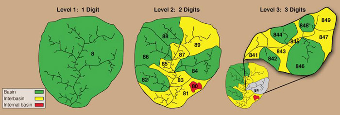
Fig. 1 The Pfafstetter coding system for watershed identification A Level 0 catchment corresponds to a continental-scale size or, alternatively, one that drains into the ocean. Higher levels represent progressively finer subdivisions of the Level 0 catchment. Theoretically, the system is not limited in the number of levels. In practice, however, n = 6 to 8 levels are usually sufficient. At each level, each watershed is assigned a specific integer m, varying from m = 0 to 9, based on its location and function within the drainage network.
At each level,
watersheds are assigned into three types: (1) basin,
(2) interbasin, and
For each level, from 1 to n, the assignment of Pfafstetter codes is performed as follows:
Figure 1 shows a 3-level example of the Pfasfstetter coding system. For each level, say Level 3, the assigned digits (XYm) are appended on to the Level 2 code (XY). For instance, watershed 846 is in watershed 8 of Level 1 (coarser), in watershed 4 of Level 2 (intermediate), and it is watershed 6 of Level 3 (finer).
Fig. 1 The Pfafstetter coding system for watershed identification (Click -here- to enlarge). | |||||||||||||||||||||||
| 190819 |