|
THE CONTROL OF NATURE: ATCHAFALAYA (John McPhee, 1989)
- The Mississippi river, with its sand and silt, had created most of Louisiana, and it could not have done so by remaining
in one channel.
- The Mississippi had jumped here and there, within an arc about 200 miles wide.
- Always it is the river's purpose to get to the Gulf by the shortest and steepest gradient.
- Major shifts have occurred once in a millennium.
- The Red river had been a tributary of the Mississippi, but in the 1940's, the Atchafalaya distributary captured it and drew it away.
- It formed the letter H: the Atchafalaya and Red on the left side; the Mississippi on the right side.
- The cross piece was named Old River.
- The structure was named Old River Control Structure (ORCS).
- In times of flood, the Atchafalaya was useful as a safety valve.
- The Corps of Engineers could not plug the Atachafalaya.
- The Corps would have to built something that would give the Atchafalaya a portion of the Mississippi,
but prevent it from taking it all.
- The Corps established that 30% of the flow would go to the Atchafalaya.
- Today the Atchafalaya's waters are 10 ft lower than the Mississippi.
- Just how the Army Corps got involved in the Lower Mississipi has no easy answer.
- It started in the War of 1812.
- After that war, Congress instructed the Corps of Engineers to survey the Mississippi and its tributaries with an eye to improving inland navigation.
- In terms of hydrology, what the Corps has done at ORCS is to stop time.
- In southern Louisiana, the bed of the Mississippi river is so far below sea level that a flow of 120,000 cfs is required
to keep the ocean salt water from flowing inland.
- "Mother Nature has more time than we do. She has nothing but time."
- Prior to 1972, the Mississippi's main channel, in its relative lethargy, had given up a lot of volume to accumulations of sediment.
- High water would flow that much higher.
- Under absence of floods, channels deposit their sediment load in the bed: aggradation.
- Under floods, channel erode their beds: degradation.
- In 1973, 20 inches of precipitation fell in 36 hours.
- During the flood of 1973, a hole developed under ORCS that was deeper than a football stadium.
- Structure was founded on piles, driven though clayey peats and organic muck.
- The shallowest rock was at a depth of 7000 ft!
- The water is from the state of New York, the state of Montana, the province of Alberta.
- The floodplain is more than 100 miles wide.
- "This river used to meander all over its floodplain. People would move their tepees.
You cannot move Vicksburg."
- Rivers overflow their banks, and create natural levees.
- In response to major floods, the levees were extended and raised.
- Shreve made a bold move on the Mississippi: He cut a meander loop, which increased the flow of the Mississippi into its distributary, advancing the date of ultimate capture.
- In 1850, the levees averaged 6 ft.
- River stages, in their wide variations, became generally higher through time, as the water was presented with fewer outlets.
- Even at normal stages, the Mississippi was beginning to stand up like a large vein on the back of a hand.
- Hold by levees was the way to do the job.
- In 1882, the levees failed in 284 places.
- According to the Corps, it was important that no water be allowed to escape the river, because its full power would be most
effective in scouring the bed.
- This was the hydraulic and hydrological philosophy of the Army Corps of Engineers.
- By 1927, it was apparent that the levees were helping to aggravate the problem they were meant to solve.
- The Corps built levee fuses, which would break on purpose, releasing the pressure on the system.
- The Design Flood was called the Project Flood.
- The Atchafalaya, continuing to grow, had become, by volume of discharge, one of there or four largest rivers in the U.S.
- Compared with the Mississippi, it had a 3:1 advantage in slope.
- Every shopping center, every drainage improvement, every square foot of new pavement in nearly half the United States was accelerating
runoff toward Louisiana.
- As contributing factors grew, the river delivered more flood for less rain.
- After 1973, the flow lines were recalculated and the levees had to be raised.
- "When the river would pool against the stratosphere was only a question of time."
- The original ORCS cost 86 million dollars.
- The work of repair would increase this amount to 500 million.
- "Nobody knows where the 100-yr flood is. The data have lost their pristine character.
- "Flood across the century are getting higher, low stages lower."
- The Atchafalaya is now one of the 20 largest rivers in the world.
|
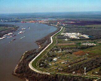
Levee on the Lower Mississippi River near Romeville, LA.
|
|
Atchafalaya slide show
Summary
- Mississippi river meanders across its flood plain.
- Holding by levees concentrates all sediment flow within the channel.
- Aggradation is caused by baseflow; degradation by floods.
- The balance of baseflow vs floods determines the net effect, either net aggradation or net degradation.
- In the Mississippi, it looks more like net aggradation.
- The Corps hoped it would be net degradation.
- The levee solution solves some problems, but it creates many other problems.
- False sense of security as floods increase in magnitude and frequency with upstream development.
- Starvation of flood plains due to nutrient shortage.
- Loss of the sight of the river.
- Paving increases the magnitude and frequency of floods.
- Based on the geomorphology, it is concluded that it is
a matter of time before the Atchafalaya becomes the master stream.
- The Army Corps of Engineers is charged by Congress not to let this happen.
|