|
SOME FACTS ABOUT
SAWYER SPRING AND ASH CREEK
SURFACE-WATER/GROUNDWATER INTERACTIONS
Victor Miguel Ponce and Gary F. Player2008
|
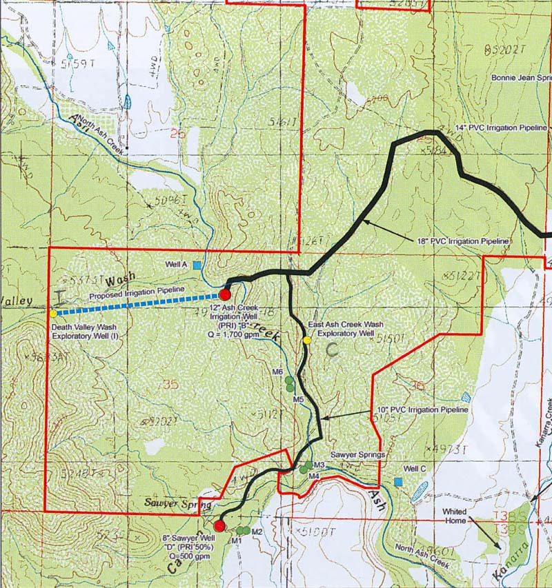
Fig. 1 Vicinity of Sawyer Spring and Ash Creek, near New Harmony, Utah (Source: LDS Church).
A. Setting
- Sawyer Spring is a tributary of Ash Creek (Fig. 1). They are located near the small town of New Harmony, in Southwestern Utah,
about 15 miles south of Cedar City.
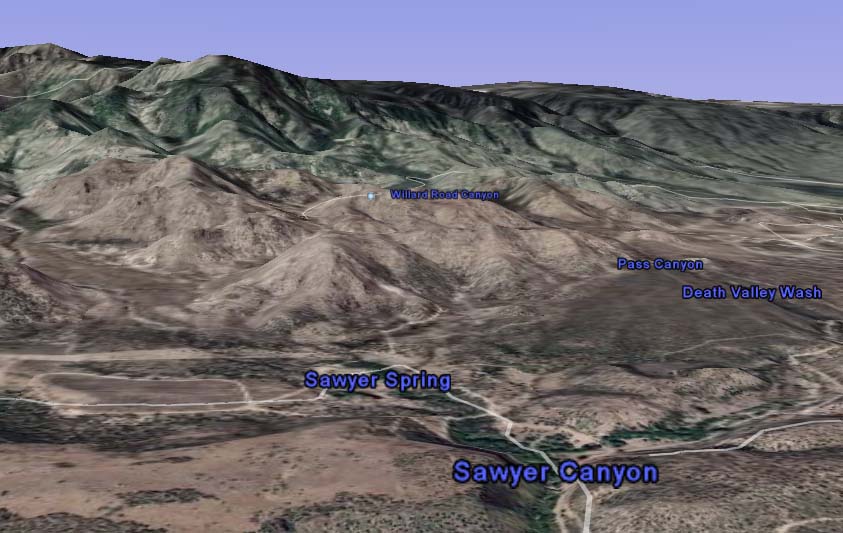
- Sawyer Spring and Ash Creek drain a shallow alluvial aquifer and the
fractured bedrock aquifer of the Pine Valley Mountains to the west. The mountains peak at 10,350 ft (Figs. 1 and 2).
- Since 1986, Mr. Bruce Whited has been farming on 300 acres of land, in the alluvial plains
downstream of Sawyer Spring and Ash Creek, at an elevation of approximately 4,850 ft.
- Mr. Whited owns water rights for all the surface flow of Sawyer Spring, and a portion of the surface flow of Ash Creek.
- These rights amount to 2.18 cfs in Sawyer Creek and 7.5 cfs in Ash Creek.
- The LDS Church owns the property upstream of Whited's farm, in the vicinity of Sawyer Spring and Ash Creek.
- The perimeter of the LDS property is shown in red color in Fig. 1.
- The location of Mr. Whited's home in shown on the bottom right-hand corner of Fig. 1.
Fig. 2 Google Earth© perspective view of Sawyer Spring, with Ash Creek to the right.
B. Pumping
- In 1993, the LDS Church drilled a 6-inch diameter well, labeled well A in Fig. 1 (light blue square),
for the purpose of exploring the availability of
groundwater.
- Well A was drilled to a depth of 400 ft.
- Also in 1993, the LDS Church drilled a 12-inch diameter irrigation well near Ash Creek, labeled well B in Fig. 1 (red circle).
- Well B was drilled to a depth of 600 ft.
- In 1993, at the time of well drilling, the depth to the water table varied between 40 and 70 ft in wells A and B.
- Well D, with an 8-inch diameter, was drilled by the LDS Church and its partners upgradient to Sawyer Spring (Fig. 1).
- In the three-year period between 1993 and 1996,
well B was pumped continuously at a rate of 750 gpm, for twenty-four hours a day, seven days a week, during the irrigation season.
- In 1997, with the availability of an electric power line and a submersible pump, the discharge at well B was increased to 1,700 gpm.
- Drawdown from this rate of discharge has eliminated surface flow of water in Sawyer Spring.
- Flow in Ash Creek has diminished greatly since groundwater production began at well B.
- Sawyer Spring was perennial until at least 1993.
- Since 1993, the flow at Sawyer Spring has frequently become intermittent or has been reduced in volume.
- Sawyer Spring has dried up every year since pumping at well B was increased to 1,700 gpm.
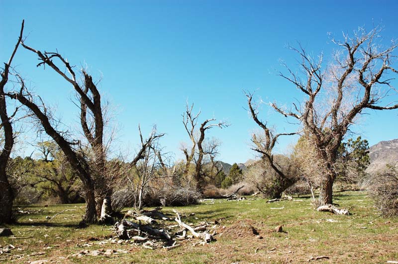
Fig. 3 Dead riparian trees near Ash Creek (photo taken May 2, 2008).
C. Lawsuit
- In 2003, Bruce Whited sued the LDS Church claiming that groundwater pumping at well B
interfered with the natural baseflow of Sawyer Spring and Ash Creek.
- Riparian vegetation (trees and shrubs) along Sawyer Spring and Ash Creek have been adversely affected by the lowering of the water table caused by the pumping at well B.
- Many trees have either died or have been substantially impaired in their normal growth and development (Fig. 3).
- In October 2007, in response to the controversy over water rights, the LDS Church stopped pumping at well B.
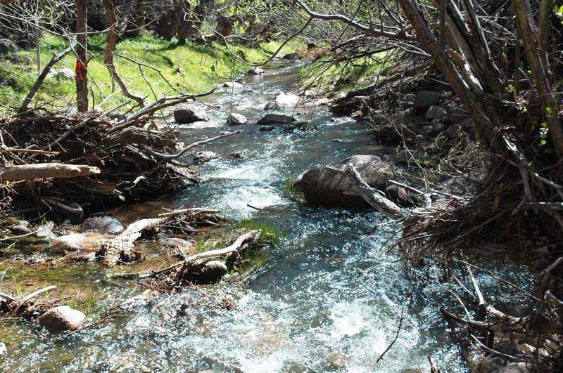
- Baseflow has resumed in Sawyer Spring and Ash Creek following the interruption of pumping at well B (Fig. 4).
- To date (May 2008), pumping at well B has not been resumed.
Fig. 4 Ash Creek on May 2, 2008, showing baseflow recovered.
|
| http://ponce.sdsu.edu/some_facts_about_sawyer_spring.html |
080529
|
|