CURVAS DE GASTO REVISITADAS
Universidad Estatal de San Diego,
California, EE.UU.
1. INTRODUCTION
A rating curve is a fundamental tool in hydraulic and hydrologic
engineering. The curve depicts the relationship between discharge and stage at a given
point in a stream, river, channel, canal, or
free-surface conduit.
Under steady uniform flow, the rating is unique, i.e., there is one value of discharge for each value of stage. The situation, however, is complicated under unsteady flow conditions.
Depending on the flow, the rating may actually be nonunique, typically
showing a histeresis, or looped rating, Further complications arise if the
flow is actually able to move its bed, as it is typically the case in alluvial
channels and/or rivers
in the absence
of geologic controls such as rock outcrops. In medium-sized to large rivers, the flow acts to minimize
the changes in stage,
effectively reducing the stage variability between low flows and high flows
(Kennedy, 1983). Nature accomplishes this feat by increasing form
friction during low flows (by means of the development of bedforms, such as ripples and dunes), and by
obliterating the bedforms during high flows, reducing form friction to negligible amounts,
leaving grain friction as the only acting type of friction.
Furthermore, unsteady, or nonequilibrium, sediment transport may also cause alterations or modifications in (previously
established) rating curves.
Rivers are typically subjecting their boundaries to recurring cycles of erosion and deposition,
depending on neighboring natural phenomena and/or anthropogenic activities.
Some active rivers may be aggrading; yet, others may be degrading.
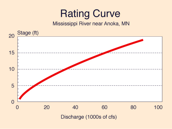
2. STEADY UNIFORM FLOW RATING
The steady uniform flow rating or equilibrium rating
is a unique relationship between discharge and stage at a given station
(Fig. 2). The curve is developed by the
simultaneous measurement of discharge and stage at a given gaging station, and by subsequently
fitting a curve to the
measured data. For increased accuracy, the site location must be free from the following conditions:
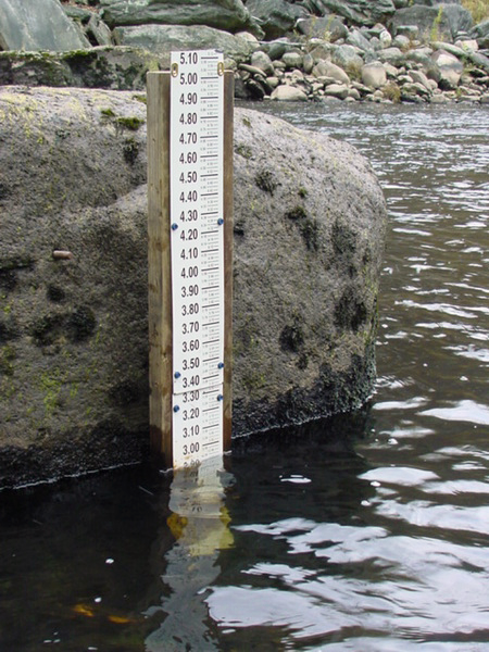
In engineering practice, the rating curve is used together with a staff gage (Fig. 3). The latter measures water surface elevation, and this value is entered to the rating curve in order to obtain the discharge of interest. Note that modern digital recorders with electronic data-transfer capabilities are becoming increasingly available for measurement automation.
The permanence of the rating is normally subject to verification by periodic stage-discharge measurements. The frecuency of the verification process will depend on whether the gaging site of interest is optimal when all relevant hydraulic factors are considered.
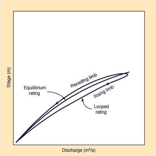
3. UNSTEADY FLOW RATING
The unsteady flow or non-equilibrium flow rating is a graph
showing a hysteresis in the rating, whereupon the actual rating curve (Fig. 4)
loops around the established equilibrium
rating.
4. SHORT-TERM SEDIMENTATION EFFECTS
The short-term sedimentation effect arises in situations
where the bottom shear stress produced by the flow
(due to the no-slip
condition at the channel boundary) is able to move its bed freely.
This is typically the case of alluvial channels/rivers,
wherein the bottom consists mostly of sand and silt particles.
Under lower regime, with Froude numbers
F < 0.5, the bottom shear will produce first, ripples,
and then, dunes, effectively increasing the
total friction, consisting of grain and form friction, the latter due to the bedforms. Under upper
regime, with Froude numbers F ≥
0.5, the comparatively large momentum of the flow will act to obliterate the lower regime
bedforms (ripples and dunes),
effectively reducing the
total friction to consist of only grain friction (see Fig. 5: E. Plane bed) (Simons and Richardson, 1966). Thus, for low flows,
the stage is higher than normal; conversely, for high flows, the stage is lower than normal.
A practical example of the short-term sedimentation effect is represented by the
so-called autodredging phenomenon, which is
well
documented in the Upper Paraguay river, in Mato Grosso,
Brazil (Ponce, 1995).
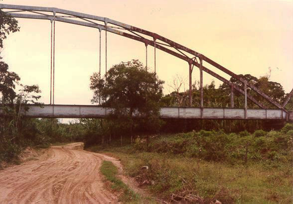
5. LONG-TERM SEDIMENTATION EFFECTS
Rivers tend to subject their boundaries to recurrent cycles of erosion
and deposition, at various spatial scales. Typical triggering
mechanisms may be represented by landslides (Fig. 5)
or nearby anthropogenic activities (Fig. 6).
Normally, properly located gaging stations are not affected by long-term sedimentation effects;
however, this cannot be guaranteed into the future.
6. ONLINE CALCULATION
Having explained in some detail
the basic concepts of rating curve hydraulics,
we now proceed to calculate the
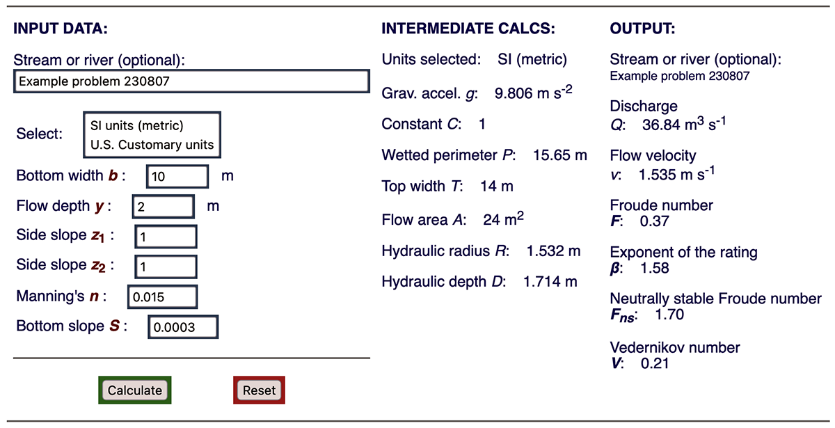
rating curve of a trapezoidal channel cross-section. To accomplish
this objective, we use the online calculator ONLINECHANNEL15B with the following
input data:
Input Data.
Bottom width b = 10 m; flow depth y = 2 m;
side slope z = 1; Manning's n = 0.015; and bottom slope
A summary of the results of the online calculator is shown in Fig. 8.
The rating equation is
Q = α A β,
in which α = 0.251, and β =
1.585.
7. SUMMARY
A review of relevant
concepts of rating curves in hydraulic and hydrologic engineering is accomplished.
Four topics are discussed: (1) steady uniform flow rating; (2) unsteady flow rating; (3) short-term
sedimentation effects; and (4) long-term sedimentation effects. The steady uniform flow rating
is unique, i.e., it features a single-valued rating, i.e.,
a unique relation between discharge and
stage.
The short-term sedimentation effect is predicated on the tendency of an alluvial
river
The long-term sedimentation effect recognizes that rivers are the authors of their own geometry,
and that they are recurrently subjected to incessant cycles of erosion and deposition,
both of natural and human-induced causes.
Therefore, the question of the permanence of a rating curve has to be taken against the reality of possible eventual geomorphic changes.
REFERENCES
Kennedy, J. F. 1983.
Reflections on rivers, research, and Rouse.
Journal of Hydraulic Engineering ASCE, 109(10), 1257-1260.
Ponce, V. M. and D. B. Simons. 1977.
Shallow wave propagation in open channel flow.
Journal of Hydraulic Engineering ASCE, 103(12), 1461-1476.
Ponce, V. M. 1995. Hydrologic and environmental impact of the Parana-Paraguay Waterway on the Pantanal of Mato
Grosso, Brazil: A reference study. San Diego State University, San Diego, California, August.
Simons, D. B., and E. V. Richardson. 1966.
Resistance to flow in alluvial channels. Geological Survey Professional Paper 422-J,
U.S. Government Printing Office, Washington, D.C.
|


| 240116 17:00 |